|
Image title
High Street, From the Country Market-place Philadelphia: with the procession in commemoration of the Death of General George Washington, December 26th: 1799
Source place of publication
[Philadelphia]
Source date
1800
Image title
An unfinished house, in Chesnut Street Philadelphia.
Source place of publication
[Philadelphia]
Source date
1800
Image title
The City & Port of Philadelphia, on the River Delaware from Kensington.
Source place of publication
[Philadelphia]
Source date
1800
Image title
Congress Hall and New Theatre, in Chesnut Street Philadelphia.
Source place of publication
[Philadelphia]
Source date
1800
Image title
Preparation for War to defend Commerce. The Swedish Church Southwark with the building of the Frigate Philadelphia.
Source place of publication
[Philadelphia]
Source date
1800
Image title
Plan of the City of Philadelphia.
Source place of publication
[Philadelphia]
Source date
1800
Image title
Arch Street Ferry, Philadelphia
Source place of publication
[Philadelphia]
Source date
1800
Image title
Old Lutheran Church, in Fifth Street Philadelphia.
Source place of publication
[Philadelphia]
Source date
1800
Image title
[Portrait of George Washington]
Source place of publication
Albany
Source date
1800
Image title
[Portrait of George Washington]
Source place of publication
Albany
Source date
1800
Image title
American Stage Waggon
Source place of publication
London
Source date
1800
Image title
Pierre Viaus throwing lighted faggots at a Bear who was climbing a tree after his Negro.
Source place of publication
London
Source date
1800
Image title
[Title page]
Source place of publication
London
Source date
1800
Title
Pour un pauvre Américain, s'il vous plait.
Image technique
Lithograph
Subject
International political scene
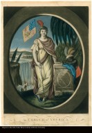
Title
Emblem of America
Image technique
Mezzotint, colored
Subject
North American political scene.
Title
GEORGEY in the COAL-HOLE
Image technique
Etching, colored
Subject
British political scene.
Title
Johnny NEW-COME in the ISLAND of JAMAICA.
Image technique
Etching, colored
Subject
Social satire
Author
Dutertre, François, b. 1760
Title
Départ du temple, pour Cayenne, des déportés des 17 et 18 fructidor, an V. : Avec les instructions curieuses données au général Dutertre, chargé de les conduire à leur destination. : Contenant un précis de la vie civile et militaire de ce général, nommé, le 19 fructidor, commandant du temple
Subject
Dutertre, François, b. 1760
Publisher
A Paris, : chez Desenne, libraire, palais Égalité. : l'auteur, rue de Regard, maison Ferdinand, F.G., no. 806.
Author
[Saint-Marc (Haiti), Port-au-Prince (Haiti), Cap-Français (Haiti), Gros Morne (Artibonite, Haiti), Port-Margot (Haiti), Fort Liberté (Haiti), Terrier-Rouge (Haiti), Marmelade (Haiti), Limonade (Haiti), Trou du Nord (Haiti), Ouest de Saint-Domingue, Nord de Saint-Domingue]
Title
Saint-Marc, le 11 germinal, an huit. L'administration munipale de Saint-marc, au citoyen Ministre de la Marine et des colonies
Subject
[Roume, Philippe Rose, Toussaint Louverture, 1743?-1803]
Publisher
Au Cap-Français [i.e. Cap-Haïtien] : chez P. Roux, imprimeur du gouvernement
Map title
Planisferio ó carta general de la tierra
Creator
[José Antonio Ximeño y Carrera, Francisco de Paula González Cañaveras, Juan Antonio González Cañaveras]
Map title
A map of the province of Upper Canada describing all the new settlements, townships, &c., with the countries adjacent, from Quebec to Lake Huron : compiled at the request of His Excellency Major General John G. Simcoe, First Lieutenant Governor /|cby David William Smyth, Esqr., Surveyor General
Creator
Smyth, David William, Sir, 1764-1837
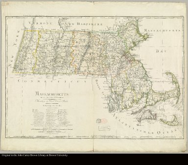
Map title
Massachusetts entworfen von D.F. Sotzmann
Creator
[Sotzmann, D. F., Schmidt, Paulus]
Map title
Vallée de Cauca depuis la Ciudad de Armas à Buga
Map title
Map of French & English grants on Lake Champlain
Creator
Pease, Richard H.
Map title
Karte von einem Theil der nordwestlichen Künste von America zu der Reise des Capit George Vancouver in den Jahren 1792, 1793 und 1794 vergüngt gezeichnet von D.F. Sotzmann
Creator
Sotzmann, D. F
Map title
Charte von West Indien nach Edwards, De la Rochette und den neuesten astronomischen beobachtungen entworfen von F. L. Güssefeld
Creator
Gð³³¥feld, F. L. (Franz Ludwig), 1744-1807
Map title
[Map of Hispaniola, Jamaica, Cuba, and the northern part of South America]
Map title
[Map of the Caribbean islands, including Puerto Rico and the Antilles or Leeward Islands]
Map title
Plan du port et de la ville de la Havane levé en 1798 par D. José del Rio Capitaine de Frégate de la Marine d'Espagne et publié par ordre du Ministre de la Marine et des Colonies, au Dépot Général de la Marine
Creator
[Rio, José del, Collin, E.]
Map title
[Plan of area near Guanabacoa, Cuba, showing location of land grant requested by Pablo Serra, ca. 1800]
Creator
Serra, Pablo, fl. ca. 1800
Map title
A Chart of Rio de la Plata, in South America, Surveyed and Drawn by Dn. Alexo. Malespina & Others and Reduced by W. Gregory.
Creator
Roper
Map title
Indicazione del Primo Viaggio intorno al Globo Terracqueo fatto dalla nave La Vittoria della Squadra di Magaglianes negli anni 1519-1522
Creator
Bordiga, F.
Map title
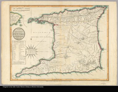
Plan of the isle of Trinidad from actual surveys made in the year 1797
Creator
Allen, George
Map title
Carta esferica que comprehende la Costa Occidental de America ... Levantada de orden del Rey N.S. en 1791 ...
Creator
Bauzá, Felipe, 1764-1833
Map title
Carte des côtes de l'Amérique Méridionale depuis le parallèle 36° 30' late. Sud jusqu'au Cap de Horn Levée en 1789, 1790, &c. par des officiers de la Marine d'Espagne. et publiée par ordre du Ministre de la Marine et des Colonies au Dépôt g��nérale de la Marine en 1800
Creator
Collin, E.
Map title
Oranda shinyaku chikyu zenzu=[The map of the whole world, newly translated from Dutch sources]
Map title
Carte des Carolines Méridionale et Septentrionale, la Georgie, la Floride, orientale et occidentale, le Pays des Cherokées, la Vaste Contrée des Muscogulges, ou la Confédération des Crek et Pays des Chataws. Pour Servir à l'Histoire des Voyages de Williams Bartram
Creator
Poirson, J. B.
Map title
Mappe-Monde ou sont tracés avec soin toutes les Isles et autres Lieux découverts Par les Voyageurs Modernes.
Map title
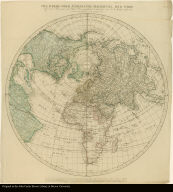
Die Obere Oder Nördliche Halbkugel Der Erde auf den Horizont von Wien Stereographisch entworfen von J. A. Ecker Aufs neue verbessert herausgegeben von P. J. Schalbacher
Map title
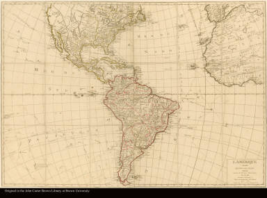
L'Amérique divisée en tous ses etatsdressée suivant les Dernières Observations par J.B. Nollin Ingénieur Géographe
Creator
Nolin, Jean Baptiste, 1686-1762
Image title
High Street, with the First Presbyterian Church. Philadelphia
Source place of publication
[Philadelphia]
Source date
1800
Image title
High Street Market. Philadelphia
Source place of publication
[Philadelphia]
Source date
1800
Image title
High Street, from Ninth Street, Philadelphia
Source place of publication
[Philadelphia]
Source date
1800
|


![[Portrait of George Washington]](http://jcb.lunaimaging.com/media/Size1/JCB-1-NA/85/8215-1.jpg?userid=2&username=jcbadmin&resolution=1&servertype=JVA&cid=1&iid=JCB&vcid=NA&usergroup=JCB-ADMIN&profileid=1)
![[Portrait of George Washington]](http://jcb.lunaimaging.com/media/Size1/JCB-1-NA/85/8215-2.jpg?userid=2&username=jcbadmin&resolution=1&servertype=JVA&cid=1&iid=JCB&vcid=NA&usergroup=JCB-ADMIN&profileid=1)


![[Title page]](http://jcb.lunaimaging.com/media/Size1/D1026/10261004.jpg?userid=2&username=jcbadmin&resolution=1&servertype=JVA&cid=1&iid=JCB&vcid=NA&usergroup=JCB-ADMIN&profileid=1)


![[Orinoco River, 1800]](https://jcb.lunaimaging.com/media/Size2/JCBMAPS-1-NA/1026/C-7412-000.jpg)

![[Upper Orinoco River, 1800]](https://jcb.lunaimaging.com/media/Size2/JCBMAPS-1-NA/1026/C-7414-000.jpg)
![[Orinoco River] d'après Caulin, [1800]](https://jcb.lunaimaging.com/media/Size2/JCBMAPS-1-NA/1026/C-7415-000.jpg)


![[Map of Hispaniola, Jamaica, Cuba, and the northern part of South America]](https://jcb.lunaimaging.com/media/Size1/JCBMAPS-1-NA/1043/C-7630-001.jpg)
![[Map of the Caribbean islands, including Puerto Rico and the Antilles or Leeward Islands]](https://jcb.lunaimaging.com/media/Size1/JCBMAPS-1-NA/1043/C-7630-002.jpg)

![[Plan of area near Guanabacoa, Cuba, showing location of land grant requested by Pablo Serra, ca. 1800]](https://jcb.lunaimaging.com/media/Size2/JCBMAPS-1-NA/1043/C-6924-000.jpg)


![Oranda shinyaku chikyu zenzu=[The map of the whole world, newly translated from Dutch sources]](https://jcb.lunaimaging.com/media/Size4/JCBMAPS-1-NA/1071/31347-000.jpg)
![[Title page]](https://jcb.lunaimaging.com/MediaManager/srvr?mediafile=/Size1/JCBMAPS~1~1/414/03081-001.jpg)