|
Map title
Carta da navegar de Nicolo et Antonio Zeni furono III tramontana lano M.CCC.LXXX.
Map title
A Map of the North-Pole and the parts adioining.
Creator
Moses Pitt
Map title
[Polar projection of Arctic]
Creator
Henricus Glareanus
Map title
[Polar projection of Antarctica]
Creator
Henricus Glareanus
Map title
Grønlandia antigua Secundum utramque partem Orientalem & Occidentalem seu Wester et Oster-Bygd delineata cum sinibus et adjacentibus Insulis et Scopulis
Map title
A Map exhibiting Mr. Hearne's tracks in his two Journies for the discovery of the Copper Mine River ...
Creator
Samuel John Neele
Map title
Mapa de la America Septentl. asia oriental y mar del sur intermedio formado sobre las Memorias mas recientes y exactas hasta el año de 1754
Creator
Manuel Rodriguez
Map title
Nouvelle Carte des Decouvertes faites par des Vaisseaux Russes aux côtes inconnues de l'Amerique Septentrionale Avec les Pais Adiacents ...
Map title
Karta Predstavliaiushaia Izobretehiia Rossiiskimi Moreplavatelianmi na Severnoi chasti Ameriki ...
Map title
Nouvelle Carte des Endroits, où l'on a taché de découvirir en 1746 & 1747 un Passage par le Nord-ouëst, avec les Routes, que les Vaisseaux ont tenues ... Nieuwe Kaart ....
Creator
Nicolaes van Frankendaal
Map title
A Chart of the North Part of America. Describing the sea Coast of Groenland ...
Creator
John Seller
Map title
Chart of the Discoveries & Route of his Majesty's Ships Hecla and Griper in search of a North West Passage, ...
Creator
[J. Walker, John Bushnan]
Map title
Map Shewing the Discoveries made by British Officers in the Arctic Regions, from the Year 1818 to 1826
Creator
J. Walker
Map title
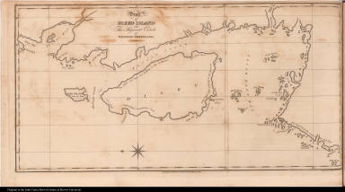
Draft of Disko Island and The Adjacent Coasts of Western Greenland.
Creator
J. C. Russell
Map title
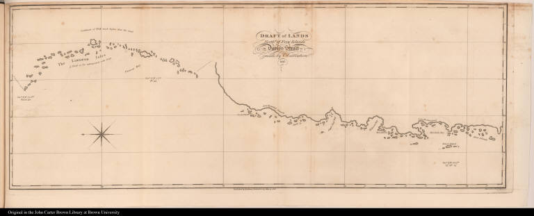
Draft of Lands Northd. of Frow Islands in Davis's Strait made by Observation. 1817.
Creator
J. C. Russell
Map title
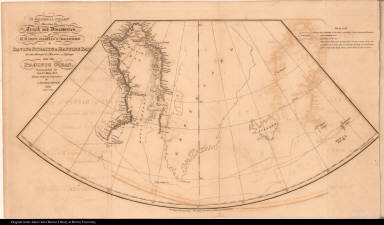
A General Chart Shewing the Track and Discoveries of H.M. Ships Isabella & Alexander to Davis's Straits & Baffin's Bay ...
Creator
[John Bushnan, J. Walker]
Map title
Plan of the Part of Baffins Bay which was found to be Inhabited.
Creator
J. Walker
Map title
General Chart shewing the track of H. M. Ships Fury and Hecla, on a Voyage for the Discovery of a North West Passage, AD. 1821 -22 -23.
Creator
J. Walker
Map title
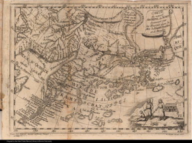
Carte du nouvel Archipel du Nord decouvert par les Russes dans la Mer de Kamtschatka et d'Anadir.
Creator
[Ionath. Lenz, G. C. Kilian]
Map title
An Outline to shew the Connected Discoveries of Captains Ross, Parry & Franklin, in the years 1818, 19, 20 and 21.
Creator
J. Walker
Map title
A Mapp of the Regions & Countreyes under and a bout [about] the North Pole
Creator
John Seller
Map title
Oud-Groenland, of deszelfs Oost-en West Kust doorgaans genaamt, Oster-Bygd en Wester-Bygd.
Map title
Kaart over Fiskernaesserts Distrikt sammenstillet efter Udkast af Rensjaegeren Benjamin Peter o: A: af S: Kleinschmiedt
Creator
Kleinschmidt, Samuel, 1814-1886
Map title
[Plan of "Terra Sancta non adhuc satis"]
Map title
[Plan of "Terra Sancta non adhuc satis"]
Map title
Caerte van Nova Zembla, de Weygats, de custe van Tartarien en Ruslandt tot Kilduyn toc ...
Creator
Baptista a Doetechum
Map title
Tabula geogr. in qua admirande navigationis cursus et recursus designatur
Map title
Continent Meridional Austral ou Antarctique
Map title
Nouvelle Guinée et Carpentarie
Map title
Nouveau Continent ou Amerique
Map title
Nouvelle représentation des côtes nord et est de l'Asie pour servir d'éclaircissement aux articles du supplément de l'encyclopédie qui concernent le passage aux Indes par le nord gravée sous la direction de Mr. de Vaugondy en 1772
Creator
Robert de Vaugondy, Didier, 1723-1786
Map title
[top] Carte des nouvelles découvertes dressée par Phil. Buache Pr. Géogr. du Roi présentée à l'Acad? des Sciences le 9 aout 1752 et approuvée dans son assemblée du 6 septembre suivant [bottom] Extrait d'une carte japonoise de l'univers apportée en Europe par Kaempfer et deposée dans le cabinet de feu Mr. Han-Sloane president de la Société royale de Londres
Creator
[Robert de Vaugondy, Didier 1723-1786, Buache, Philippe, 1700-1773]
Map title
Carte générale des découvertes de l'Amiral de Fonte, et autres navigateurs espagnols, anglois et russes pour la recherche du passage à la Mer du Sud par M. De l'Isle de l'Académie Royale des Sciences &c. ; publiée a Paris en Septembre 1752
Creator
[Robert de Vaugondy, Didier 1723-1786, L'Isle, Joseph Nicolas de, 1688-1768]
|

![[North polar projection]](https://jcb.lunaimaging.com/media/Size2/JCBMAPS-1-NA/map_migration/03482003.jpg)
![[Map of Arctic circle]](https://jcb.lunaimaging.com/MediaManager/srvr?mediafile=/Size1/JCBMAPS~1~1/285/02544-1.jpg)

![[Polar projection of Arctic]](https://jcb.lunaimaging.com/media/Size1/JCBMAPS-1-NA/map_migration/01361004.jpg)
![[Polar projection of Antarctica]](https://jcb.lunaimaging.com/media/Size1/JCBMAPS-1-NA/map_migration/01331002.jpg)

![[South polar projection]](https://jcb.lunaimaging.com/media/Size2/JCBMAPS-1-NA/map_migration/01802004.jpg)


![A Mapp of the Regions & Countreyes under and a bout [about] the North Pole](https://jcb.lunaimaging.com/media/Size2/JCBMAPS-1-NA/map_migration/09722002.jpg)


![[Plan of "Pamphagonia"]](https://jcb.lunaimaging.com/media/Size2/JCBMAPS-1-NA/1087/06107-003.jpg)
![[Plan of "Terra Sancta non adhuc satis"]](https://jcb.lunaimaging.com/media/Size2/JCBMAPS-1-NA/1087/06107-004.jpg)
![[Plan of "Viraginia"]](https://jcb.lunaimaging.com/media/Size2/JCBMAPS-1-NA/1087/06107-005.jpg)
![[Plan of "Viraginia"]](https://jcb.lunaimaging.com/media/Size2/JCBMAPS-1-NA/1087/01606-003.jpg)
![[Plan of "Pamphagonia"]](https://jcb.lunaimaging.com/media/Size2/JCBMAPS-1-NA/1087/01606-004.jpg)
![[Plan of "Terra Sancta non adhuc satis"]](https://jcb.lunaimaging.com/media/Size2/JCBMAPS-1-NA/1087/01606-005.jpg)
![[Title page]](https://jcb.lunaimaging.com/media/Size1/JCBMAPS-1-NA/1097/08282-001.jpg)
![[Map of Novaya Zemblya]](https://jcb.lunaimaging.com/media/Size1/JCBMAPS-1-NA/1097/08282-002.jpg)
![[Map of Novaya Zemblya]](https://jcb.lunaimaging.com/media/Size1/JCBMAPS-1-NA/1097/08282-003.jpg)

![[Map of Lapland]](https://jcb.lunaimaging.com/media/Size1/JCBMAPS-1-NA/1097/08282-005.jpg)
![[Map of Lapland and Kildin Island]](https://jcb.lunaimaging.com/media/Size1/JCBMAPS-1-NA/1097/08282-006.jpg)


![[top] Carte des nouvelles découvertes dressée par Phil. Buache Pr. Géogr. du Roi présentée à l'Acad? des Sciences le 9 aout 1752 et approuvée dans son assemblée du 6 septembre suivant [bottom] Extrait d'une carte japonoise de l'univers apportée en Europe par Kaempfer et deposée dans le cabinet de feu Mr. Han-Sloane president de la Société royale de Londres](https://jcb.lunaimaging.com/media/Size2/JCBMAPS-1-NA/1013/15219-000.jpg)

