|
Image title
[Our Lady of Guadalupe]
Source place of publication
Impresso en Mexico
Source date
1755
Title
BRITAIN'S RIGHTS maintaind; or FRENCH AMBITION dismantled. Addrest to the Laudable Societys of ANTI-GALICANS, The generous Promoters of British Arts & Manufactories By ... a lover of His country.
Image technique
Etching
Subject
Seven Years' War
Title
BRITISH RESENTMENT or the FRENCH fairly COOPT at Louisbourg
Image technique
Etching, colored
Subject
Seven Years' War
Title
THE GRAND MONARQUE in a Fright: Or the BRITISH LION rous'd from his Lethargy
Image technique
Etching
Subject
Seven Years' War
Title
THE THREE RENOWNED HIBERNIAN HEROES
Image technique
Etching
Subject
Seven Years' War
Title
BRITISH RESENTMENT or the FRENCH fairly COOPT at Louisbourg
Image technique
Etching, colored
Subject
Seven Years' War
Title
Inventory of druggs belonging to the estate of Doctr. David Vanderlight deceasd.
Subject
Vanderlight, David, 1726-1755; Vanderlight, Mary, 1731-1795; Drugs -- Inventories; Inventories of decedents' estates -- Rhode Island -- Providence; Manuscripts, English -- Rhode Island -- Providence; Manuscripts -- English; Imprint 1755
Author
[Lambert, Claude-François, 1705-1765, Howard, Edward, Esq, Green, James. fmo RPJCB]
Title
Travels through Asia, Africa, and America. : Containing a curious account of the manners, customs, usages, different languages, government, ceremonies, religion, history, commerce, arts, and sciences, &c. of those several nations. By Edward Howard, Esq.
Subject
[Chiquito Indians, Guarani Indians, Indians of North America, Indians of the West Indies, Indigo industry, Taino Indians]
Publisher
London : Printed for M. Cooper, in Pater-Noster-Row.
Map title
A Map of the most Inhabited part of Virginia containing the whole Province of Maryland with Part of Pensilvania, New Jersey and North Carolina
Creator
[Peter Jefferson, Joshua Fry]
Map title
A Map of the most Inhabited part of Virginia containing the whole Province of Maryland with Part of Pensilvania, New Jersey and North Carolina
Creator
[Peter Jefferson, Joshua Fry]
Map title
A Map of the most Inhabited part of Virginia containing the whole Province of Maryland with Part of Pensilvania, New Jersey and North Carolina
Creator
[Peter Jefferson, Joshua Fry]
Map title
A Map of the most Inhabited part of Virginia containing the whole Province of Maryland with Part of Pensilvania, New Jersey and North Carolina
Creator
[Peter Jefferson, Joshua Fry]
Map title
Mapa y Tabla Geografica de Leguas comunes, que ai de unos à otros Lugares, y Ciudades principales de la America septentrional
Creator
Joseph Nava
Map title
A new Map of North America, wherein is exactly described all ye. European Settlements, with whatever else is remarkable in the West Indies ...
Creator
Richard William Seale
Map title
The British & French Dominions in North America Particularly Shewing the French Encroachments through all the British Plantations from Nova Scotia down to the Gulf of Mexico.
Map title
A general map of the middle British colonies, in America; viz. Virginia, Mariland, Delaware, Pensilvania, New-Jersey, New-York, Connecticut, and Rhode Island: Of Aquanishuonîgy, the country of the Confederate Indians; comprehending Aquanishuonîgy proper, their place of residence, Ohio and Tïiuxsoxrúntie, their deer-hunting countries, Couxsaxráge and Skaniadarâde, their beaver-hunting countries; of the Lakes Erie, Ontário, and Champlain, and part of New-France: Wherein is also shewn the antient and present seats of the Indian nations by Lewis Evans. 1755
Creator
[Evans, Lewis, 1700?-1756, Turner, James, d. 1759]
Map title
A new map of Nova Scotia, and Cape Britain with the adjacent parts of New England and Canada, composed from a great number of actual surveys; and other materials regulated by many new astronomical observations of the longitude as well as latitude; with an explanation
Creator
Jefferys, Thomas, d. 1771
Map title
A large and particular plan of Shegnekto bay, and the circumjacent country, with the forts and settlements of the French 'till dispossess'd by the English in June 1755 drawn on the Spot by an officer
Map title
Mapa de la America Septentrional dividido en dos partes delineado por Lopez y Cruz. Año de 1755
Map title
[A map of the most inhabited part of New England containing the provinces of Massachusets Bay and New Hampshire, with the colonies of Konectikut and Rhode Island, divided into counties and townships: ...]
Creator
[Jefferys, Thomas, d. 1771, Green, John, d. 1757]
Map title
Carta d'una parte dell' America Settentrionale che serve per ben poter intendere le pretensioni delli Inglesi, esposte ne loro memoriali in occasione della regolazione de limiti con la Francia nell' America svdetta
Map title
Mapa de la America Septentrional dividido en dos partes delineado por Lopez y Cruz. Año de 1755
Map title
A map of the most inhabited part of New England containing the provinces of Massachusets Bay and New Hampshire, with the colonies of Konectikut and Rhode Island, divided into counties and townships: ...
Creator
[Jefferys, Thomas, d. 1771, Green, John, d. 1757]
Map title
A map of New England & ye country adjacent, extending northward to Quebec, & westward to Niagara, on Lake Ontario shewing gen: Shirley and gen: Iohnson's routs, & many places omitted in other maps; communicated by a gentleman who resided in these parts
Map title
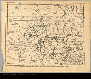
A map of the five Great Lakes with part of Pensilvania, New York, Canada and Hudsons Bay territories &c.
Map title
Carte de la Virginie et du Maryland dressée sur la grande carte angloise de Mrs. Josué Fry et Pierre Jefferson par le Sr. Robert de Vaugondy, géographe ordinaire du Roi
Creator
[Robert de Vaugondy, Gilles, 1688-1766, Haussard, Elisabeth]
Map title
[Map of Central America and southern North America, including Caribbean islands]
Creator
López de Vargas Machuca, Tomás, 1731-1802
Map title
[Map of Caribbean islands and the northern part of South America]
Creator
López de Vargas Machuca, Tomás, 1731-1802
Map title
[right half] Map of the western half of Jamaica
Creator
[Browne, Patrick, 1720?-1790, Bayly, I.]
Map title
[right half] Map of the eastern half of Jamaica
Creator
[Browne, Patrick, 1720?-1790, Bayly, I.]
Map title
The Draught of Genl. Braddocks Route towards Fort DuQuesne as deliver'd to Capt. McKeller Engineer
Creator
Gist, Christopher, ca. 1706-1759
Map title
Partie Occidentale de la Nouvelle France ou Canada
Creator
Bellin, Jacques Nicolas,1703-1772
Map title
Partie Orientale de la Nouvelle France ou du Canada
Creator
Bellin, Jacques Nicolas,1703-1772
Map title
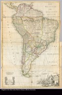
South America corrected from the observation communicated to the Royal Society"s of London & Paris by John Senex, at the Globe against St. Dunstans Church Fleetstreet
Creator
Senex, John, d. 1740
Map title
[cartouche of map of North America]
Creator
[Mitchell, John, 1711-1768, Kitchin, Thomas, d. 1784]
Map title
[lower right middle of map of North America]
Creator
[Mitchell, John, 1711-1768, Kitchin, Thomas, d. 1784]
Map title
[lower left middle of map of North America]
Creator
[Mitchell, John, 1711-1768, Kitchin, Thomas, d. 1784]
Map title
[lower left of map of North America]
Creator
[Mitchell, John, 1711-1768, Kitchin, Thomas, d. 1784]
Map title
[upper right of map of North America]
Creator
[Mitchell, John, 1711-1768, Kitchin, Thomas, d. 1784]
Map title
[upper middle right of map of North America]
Creator
[Mitchell, John, 1711-1768, Kitchin, Thomas, d. 1784]
Map title
[upper left of map of North America]
Creator
[Mitchell, John, 1711-1768, Kitchin, Thomas, d. 1784]
Map title
[upper middle left of map of North America]
Creator
[Mitchell, John, 1711-1768, Kitchin, Thomas, d. 1784]
Map title
Carolinae Floridae nec non insularum Bahamensium cum partibus adjacendibus delineation
Map title
[Sheet 1: Great Lakes]
Creator
Mitchell, John, 1711-1768
Map title
[Sheet 2: Hudson Bay and north central North America]
Creator
Mitchell, John, 1711-1768
Map title
[Sheet 3: Chesapeake Bay, New Jersey, Delaware, Maryland, Virginia, and North Carolina]
Creator
Mitchell, John, 1711-1768
Map title
[Sheet 4: Labrador, Nova Scotia, and Newfoundland]
Creator
Mitchell, John, 1711-1768
|
![[Our Lady of Guadalupe]](https://jcb.lunaimaging.com/MediaManager/srvr?mediafile=/Size1/JCB~1~1/250/06808.jpg)


![[A map of the most inhabited part of New England containing the provinces of Massachusets Bay and New Hampshire, with the colonies of Konectikut and Rhode Island, divided into counties and townships: ...]](https://jcb.lunaimaging.com/media/Size2/JCBMAPS-1-NA/1019/31288-001.jpg)


![[Map of Central America and southern North America, including Caribbean islands]](https://jcb.lunaimaging.com/media/Size1/JCBMAPS-1-NA/1042/14552-001.jpg)
![[Map of Caribbean islands and the northern part of South America]](https://jcb.lunaimaging.com/media/Size1/JCBMAPS-1-NA/1042/14552-002.jpg)
![[right half] Map of the western half of Jamaica](https://jcb.lunaimaging.com/media/Size1/JCBMAPS-1-NA/1044/10964-001.jpg)
![[right half] Map of the eastern half of Jamaica](https://jcb.lunaimaging.com/media/Size1/JCBMAPS-1-NA/1044/10964-002.jpg)


![[cartouche of map of North America]](https://jcb.lunaimaging.com/media/Size1/JCBMAPS-1-NA/1069/36867-001.jpg)
![[lower right middle of map of North America]](https://jcb.lunaimaging.com/media/Size1/JCBMAPS-1-NA/1069/36867-002.jpg)
![[lower left middle of map of North America]](https://jcb.lunaimaging.com/media/Size1/JCBMAPS-1-NA/1069/36867-003.jpg)
![[lower left of map of North America]](https://jcb.lunaimaging.com/media/Size1/JCBMAPS-1-NA/1069/36867-004.jpg)
![[upper right of map of North America]](https://jcb.lunaimaging.com/media/Size1/JCBMAPS-1-NA/1069/36867-005.jpg)
![[upper middle right of map of North America]](https://jcb.lunaimaging.com/media/Size1/JCBMAPS-1-NA/1069/36867-006.jpg)
![[upper left of map of North America]](https://jcb.lunaimaging.com/media/Size1/JCBMAPS-1-NA/1069/36867-008.jpg)
![[upper middle left of map of North America]](https://jcb.lunaimaging.com/media/Size1/JCBMAPS-1-NA/1069/36867-007.jpg)

![[Sheet 1: Great Lakes]](https://jcb.lunaimaging.com/media/Size1/JCBMAPS-1-NA/1001/15468a.jpg)
![[Sheet 2: Hudson Bay and north central North America]](https://jcb.lunaimaging.com/media/Size1/JCBMAPS-1-NA/1001/15468b.jpg)
![[Sheet 3: Chesapeake Bay, New Jersey, Delaware, Maryland, Virginia, and North Carolina]](https://jcb.lunaimaging.com/media/Size1/JCBMAPS-1-NA/1001/15468c.jpg)
![[Sheet 4: Labrador, Nova Scotia, and Newfoundland]](https://jcb.lunaimaging.com/media/Size1/JCBMAPS-1-NA/1001/15468d.jpg)
![[Sheet 5: Cartouche]](https://jcb.lunaimaging.com/media/Size1/JCBMAPS-1-NA/1001/15468e.jpg)