|
REFINE
Browse All : Images by Toms, William Henry
1-22 of 22
Map title
[Northern tip of Newfoundland with 2 vignettes of Quebec and New York cities]
Creator
Toms, William Henry
Map title
[North America showing headwaters of the Mississippi River]
Creator
Toms, William Henry
Map title
[North America showing the Great Lakes]
Creator
Toms, William Henry
Map title
[North America with Nova Scotia to Cape Cod]
Creator
Toms, William Henry
Map title
[George's Banks off of Newfoundland with 3 insets: the harbors at Placentia, Annapolis Royal, and Boston]
Creator
Toms, William Henry
Map title
[North America showing the mouth of the Mississippi River and the Gulf of Mexico]
Creator
Toms, William Henry
Map title
[Southeastern North America showing the coast from Virginia to Florida]
Creator
Toms, William Henry
Map title
[Map of Atlantic Ocean]
Creator
Toms, William Henry
Map title
[Insets of the harbors of New York, Charleston, S.C., Saint Augustine, Florida, and Providence, Bermuda, along with a map of Bermuda]
Creator
Toms, William Henry
Map title
[Mexico and Central America]
Creator
Toms, William Henry
Map title
[Caribbean islands, showing Cuba and upper Antilles]
Creator
Toms, William Henry
Map title
[Caribbean islands, showing lower Antilles]
Creator
Toms, William Henry
Map title
[Insets of the harbor at Havana, and Saint Iago in Cuba, Kingston and Port Antonio in Jamaica, and Fort Royal in Martinique]
Creator
Toms, William Henry
Map title
[Cartouche showing the arrival of Europeans to America]
Creator
Toms, William Henry
Map title
[Map of Central America to the northeastern part of South America]
Creator
Toms, William Henry
Map title
[Map of the northwestern part of South America]
Creator
Toms, William Henry
Map title
[Inset maps of Barbados, Antiqua, the harbors of Cartagena and Porto Bello]
Creator
Toms, William Henry
Map title
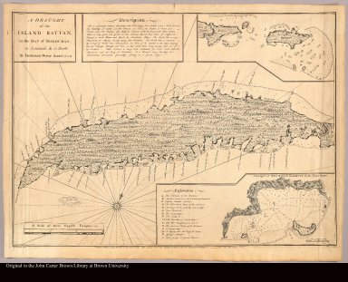
A draught of the Island Rattan, in the Bay of Honduras, in latitude 16?22' North by Lieutenant Henry Barnsley 1742
Creator
[Barnsley, Henry, d. 1757, Toms, William Henry]
Map title
[Key map]
Creator
[Popple, Henry, d. 1743, Toms, William Henry]
Map title
[Canada to Lake Superior with 2 vignettes of Niagara Falls and Mexico City]
Creator
Toms, William Henry
Map title
[Canada from Hudson's Bay to Lake Nipissing]
Creator
Toms, William Henry
1-22 of 22
|
![[Northern tip of Newfoundland with 2 vignettes of Quebec and New York cities]](https://jcb.lunaimaging.com/media/Size1/JCBMAPS-1-NA/1013/34627-005.jpg)
![[North America showing headwaters of the Mississippi River]](https://jcb.lunaimaging.com/media/Size2/JCBMAPS-1-NA/1013/34627-006.jpg)
![[North America showing the Great Lakes]](https://jcb.lunaimaging.com/media/Size2/JCBMAPS-1-NA/1013/34627-007.jpg)
![[North America with Nova Scotia to Cape Cod]](https://jcb.lunaimaging.com/media/Size2/JCBMAPS-1-NA/1013/34627-008.jpg)
![[George's Banks off of Newfoundland with 3 insets: the harbors at Placentia, Annapolis Royal, and Boston]](https://jcb.lunaimaging.com/media/Size1/JCBMAPS-1-NA/1013/34627-009.jpg)
![[North America showing the mouth of the Mississippi River and the Gulf of Mexico]](https://jcb.lunaimaging.com/media/Size2/JCBMAPS-1-NA/1013/34627-010.jpg)
![[Southeastern North America showing the coast from Virginia to Florida]](https://jcb.lunaimaging.com/media/Size2/JCBMAPS-1-NA/1013/34627-011.jpg)
![[Map of Atlantic Ocean]](https://jcb.lunaimaging.com/media/Size2/JCBMAPS-1-NA/1013/34627-012.jpg)
![[Insets of the harbors of New York, Charleston, S.C., Saint Augustine, Florida, and Providence, Bermuda, along with a map of Bermuda]](https://jcb.lunaimaging.com/media/Size1/JCBMAPS-1-NA/1013/34627-013.jpg)
![[Mexico and Central America]](https://jcb.lunaimaging.com/media/Size2/JCBMAPS-1-NA/1013/34627-014.jpg)
![[Caribbean islands, showing Cuba and upper Antilles]](https://jcb.lunaimaging.com/media/Size2/JCBMAPS-1-NA/1013/34627-015.jpg)
![[Caribbean islands, showing lower Antilles]](https://jcb.lunaimaging.com/media/Size2/JCBMAPS-1-NA/1013/34627-016.jpg)
![[Insets of the harbor at Havana, and Saint Iago in Cuba, Kingston and Port Antonio in Jamaica, and Fort Royal in Martinique]](https://jcb.lunaimaging.com/media/Size1/JCBMAPS-1-NA/1013/34627-017.jpg)
![[Cartouche showing the arrival of Europeans to America]](https://jcb.lunaimaging.com/media/Size2/JCBMAPS-1-NA/1013/34627-018.jpg)
![[Map of Central America to the northeastern part of South America]](https://jcb.lunaimaging.com/media/Size2/JCBMAPS-1-NA/1013/34627-019.jpg)
![[Map of the northwestern part of South America]](https://jcb.lunaimaging.com/media/Size2/JCBMAPS-1-NA/1013/34627-020.jpg)
![[Inset maps of Barbados, Antiqua, the harbors of Cartagena and Porto Bello]](https://jcb.lunaimaging.com/media/Size1/JCBMAPS-1-NA/1013/34627-021.jpg)
![[Key map]](https://jcb.lunaimaging.com/media/Size1/JCBMAPS-1-NA/1013/34627-001.jpg)
![[Canada to Lake Superior with 2 vignettes of Niagara Falls and Mexico City]](https://jcb.lunaimaging.com/media/Size2/JCBMAPS-1-NA/1013/34627-002.jpg)
![[Canada from Hudson's Bay to Lake Nipissing]](https://jcb.lunaimaging.com/media/Size2/JCBMAPS-1-NA/1013/34627-003.jpg)
![[Eastern Canada showing Saint Lawrence River and Newfoundland]](https://jcb.lunaimaging.com/media/Size2/JCBMAPS-1-NA/1013/34627-004.jpg)