|
REFINE
Browse All : Images by Thos. Jefferys
1-9 of 9
Map title
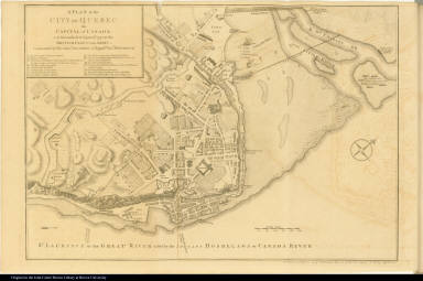
A Plan of the City of Quebec the Capital of Canada. ...
Map title
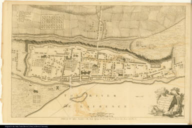
Plan of the Town and Fortifications of Montreal or Ville Marie in Canada.
Map title
[left] A Plan of the City, and Fortifications, of Louisburg; ... [right] A Plan of the City and Harbour of Louisburg, ... [lower right] A Map of Gabarus Bay adjoyning to Louisburg.
Map title
[left] Plan of New Orleans the Capital of Louisiana; ... in the year 1720.; [upper right] The Course of Mississipi [sic] River, from Bayagoulas to the Sea.; [lower right] The East Mouth of the Mississipi [sic], with the Plan of Fort La Balise ...
Map title
An Authentic Plan of the Town and Harbour of Cap-Francois in the Isle of St. Domingo.
Creator
Thomas Jefferys
Map title
Plan of the Town and Citadel of Fort Royal the Capital of Martinico. with the Bay of Cul de Sac Royal.
Creator
Mr. de Caylus
Map title
Plan of the Town and Fort of Grenada.
Creator
[Thomas Jefferys, Mr. de Caylus]
Map title
The Island and Colony of Cayenne subject to the French, on the Continent of South America.
Creator
Thomas Jefferys
Map title
A new map of Nova Scotia, and Cape Britain with the adjacent parts of New England and Canada, composed from a great number of actual surveys; and other materials regulated by many new astronomical observations of the longitude as well as latitude; with an explanation
Creator
Jefferys, Thomas, d. 1771
1-9 of 9
|
![[left] A Plan of the City, and Fortifications, of Louisburg; ... [right] A Plan of the City and Harbour of Louisburg, ... [lower right] A Map of Gabarus Bay adjoyning to Louisburg.](https://jcb.lunaimaging.com/media/Size2/JCBMAPS-1-NA/map_migration/09482004.jpg)
![[left] Plan of New Orleans the Capital of Louisiana; ... in the year 1720.; [upper right] The Course of Mississipi [sic] River, from Bayagoulas to the Sea.; [lower right] The East Mouth of the Mississipi [sic], with the Plan of Fort La Balise ...](https://jcb.lunaimaging.com/media/Size2/JCBMAPS-1-NA/map_migration/09492002.jpg)


