|
REFINE
Browse All : Images by Fisher, Joshua, 1707-1783
1-5 of 5
Map title
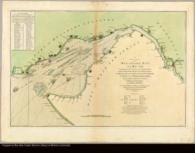
A chart of Delaware Bay and River containing a full & exact description of the shores, creeks, harbours, soundings, shoals, sands, and bearings of the most considerable land marks, from the capes to Philadelphia taken from the original chart published at Philadelphia by Joshua Fisher
Creator
Fisher, Joshua, 1707-1783
Map title
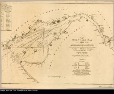
A chart of Delaware Bay and River containing a full and exact description of the shores, creeks, harbours, soundings, shoals, sands, and bearings of the most considerable land marks, from the capes to Philadelphia. Taken from the original chart published at Philadelphia by Joshua Fisher
Creator
Fisher, Joshua, 1707-1783
Map title
Carte de la baye et rivière de Délaware contenant une éxacte et entiére description des rivages, criques, havres, sondes, bas-sonds, sables et les gissements des marques les plus considérables du pays, depuis les caps James et May jusqu'à Philadelphie, suivant la carte originale publiée en cette ville, par Josué Fischer. Rédigé, d'après un plan anglois au Dépôt général des cartes, plans et journaux de la marine. Par ordre de M. de Sartine, conseiller d'Etat, Ministre et Secretaire d'Etat au Département de la marine. Petit, sculp
Creator
[Fisher, Joshua, 1707-1783, Petit]
Map title
A chart of Delaware Bay and River containing a full and exact description of the shores, creeks, harbours, soundings, shoals, sands, and bearings of the most considerable land marks, from the capes to Philadelphia. Taken from the original chart published at Philadelphia by Joshua Fisher
Creator
[Fisher, Joshua, 1707-1783, Haydon, William, active 1776-1794]
Map title
To the merchants & insurers of the City of Philadelphia this chart of Delaware Bay, from the sea-coast to Reedy-Island containing a full and exact description of the shores ... is dedicated by a friend to trade and navigation Joshua Fisher
Creator
[Fisher, Joshua, 1707-1783, Turner, James, d. 1759]
1-5 of 5
|