Log In
Register
Thumbnail Count
50
100
250
Thumbnail Size
Small
Medium
Large
Theme
Modern
Earth
Deep Sea
More Settings
Select the category to search in
All
All
-
Search Catalog Data
Annotation
Catalog Data & text in Documents
Search By Date Range
Advanced Search
COLLECTIONS
All Collections
JCB Archive of Early American Images
JCB Book Collection
JCB Books Internet Archive
JCB Map Collection
JCB Political Cartoons
John Russell Bartlett Collection
EXPLORE
Browse All
Media Groups
Presentations
External Media Search
Browse 4W Facets
Workspace
CREATE
Media Groups
Presentations
SHARE
EMBED
PRINT
HELP
REFINE
Who What Where When
REMOVE
engraved map; vol. 2, fronti …
WHAT
engraved map; vol. 2, fro … (1)
WHERE
Caribbean (1)
WHO
Du Tertre, Jean Baptiste, … (1)
F. Lapointe (1)
[Thomas Jolly] (1)
WHEN
1667 (1)
REFINE
Browse All : engraved map; vol. 2, frontispiece
1-1 of 1
1667
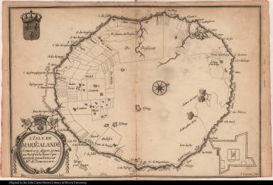
l'Isle de Mariegalande ...
Caribbean
Du Tertre, Jean Baptist...
Map title
l'Isle de Mariegalande Scituée a 15 degrez 40 min. au Nord de la ligne Equinoctiale gouvernée par Mr. de Temericourt.
Creator
F. Lapointe
1-1 of 1
Please wait while the presentation is being created...