COLLECTION NAME:
JCB Archive of Early American Images
Record
Accession number:
85-27
Record number:
85-27-6
JCB call number:
DC731 G338m
Image title:
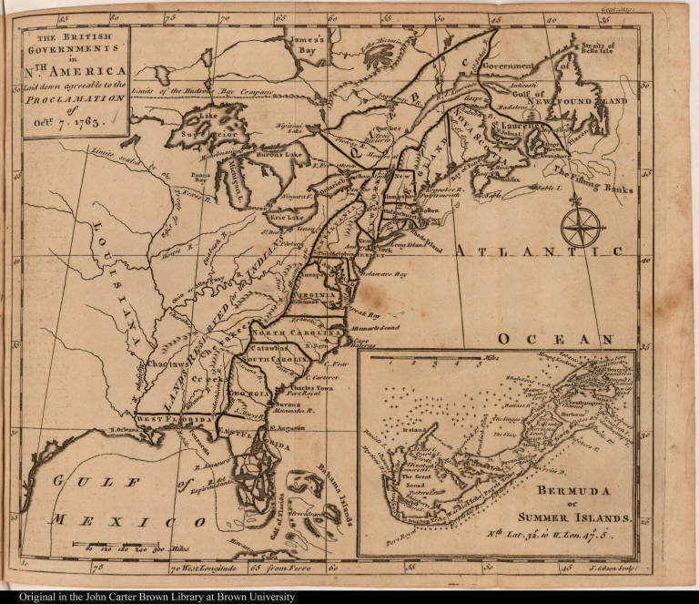
The British Governments in Nth. America Laid down agreeable to the Proclamation of Octr. 7. 1763.
Creator 1:
John Gibson
Creator 1 role:
sculp:
Place image published:
[London]
Image publisher:
[D. Henry and R. Cave]
Image date:
[1763]
Image function:
fold-out plate; vol. 33, following p. 552
Technique:
engraving
Image dimension height:
20.2 cm.
Image dimension width:
23.5 cm.
Page dimension height:
20.8 cm.
Page dimension width:
25.7 cm.
Materials medium:
ink
Materials support:
paper
Languages:
English
Description:
Map of the northeastern part of North America from Labrador south to Florida, including the Mississippi River. Also includes an inset map of Bermuda. Cartographic elements include lines of latitude and longitude (based on the Ferro meridian), compass rose, scale, sea banks or shoals, location of lands reserved for the Indians or native Americans, limits of lands reserved for the Hudson's Bay Company, and limits established by the Treaty of 1762.
Source Title:
The gentleman's magazine: and historical chronicle. Volume XXXIII.
Source place of publication:
London
Source publisher:
Printed for D. Henry and R. Cave, at St. John's Gate
Source date:
M.DCC.LXIII. [1763]
notes:
This map is described as the most significant and far-reaching policy statement for the administration of the American colonies that the British government ever issued. It delineated the boundary between the American colonies and the area given to the Indians beyond which "our people should not at present be permitted to settle." In 1762, France ceded all of its lands west of the Mississippi River to Spain in a secret treaty (the Treaty of Fontainebleau) with Spain. This treaty was kept secret even at the Treaty of Paris in 1763 which ended the Seven Year's War. Issued after England acquired new territories from Spain and France, it brought into being the new British colonies of Quebec, East Florida, West Florida, and Grenada.
Time Period:
1751-1800
References:
Cumming, W.P. Southeast in early maps, no. 336A; cf. McCorkle, B.B. New England in Early Printed Maps, 763.3
Provenance/Donor:
Acquired in 1985.
Owner and copyright:
©John Carter Brown Library, Box 1894, Brown University, Providence, R.I. 02912
geographic area:
Caribbean Islands
geographic area:
North America
Subject Area:
Geography, maps, city views and plans
Subject headings:
North America--Maps
The British Governments in Nth. America Laid down agreeable to the Proclamation of Octr. 7...