COLLECTION NAME:
JCB Map Collection
Record
Accession Number:
15229
File Name:
15229-003
Call number:
D598 P975n
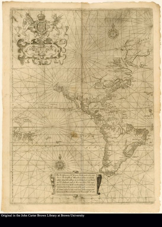
Map title:
By the discouerie of Sr Francis Drake made in the yeare 1577 ...
Place of Publication:
London
Publisher:
By George Bishop, Ralph Newberie and Robert Barker
Publication date:
1598
Map size height:
32 cm.
Map size width:
20 cm.
Item description:
fold-out engraved map; following preface
Geographical description:
A chart of North America and South America with Greenland in the upper right corner. Decorative elements include English royal coat of arms and cartouche. Nautical elements include rhumb lines, compass roses, names of rivers and cities.
Source title:
The principal nauigations, voiages, traffiques and discoueries of the English nation, made by sea or ouer-land, to the remote and farthest distant quarters of the earth, at any time within the compasse of these 1500. yeeres deuided into three seuerall volumes, according to the positions of the regions, whereunto they were directed ... And lastly, the memorable defeate of the Spanish huge Armada, anno 1588. and the famous victorie atchieued at the citie of Cadiz, 1596. are described. By Richard Hakluyt ...
Source place:
Imprinted at London: By George Bishop, Ralph Newberie and Robert Barker., 1598-1600
Cartobibliographic notes:
This is the left half of Edward Wright's (1588?-1615) map of the world. Even though Wright's name does not appear on the map, his name has been long associated with it. In 1569 Gerhard Mercator developed the projection scheme which bears his name, but he left no explanation of the process by which his projections were constructed. Wright is credited with reconstructing the mathematical formulas which Mercator used and published an explanation of it in 1599.
Geographic Area:
Western hemisphere
Normalized date:
1598
LC bibliographic number:
b25723923
By the discouerie of Sr Francis Drake made in the yeare 1577 ...