COLLECTION NAME:
JCB Map Collection
Record
Accession Number:
B07-103
File Name:
B07-103-000
Call number:
Cabinet En763 /2
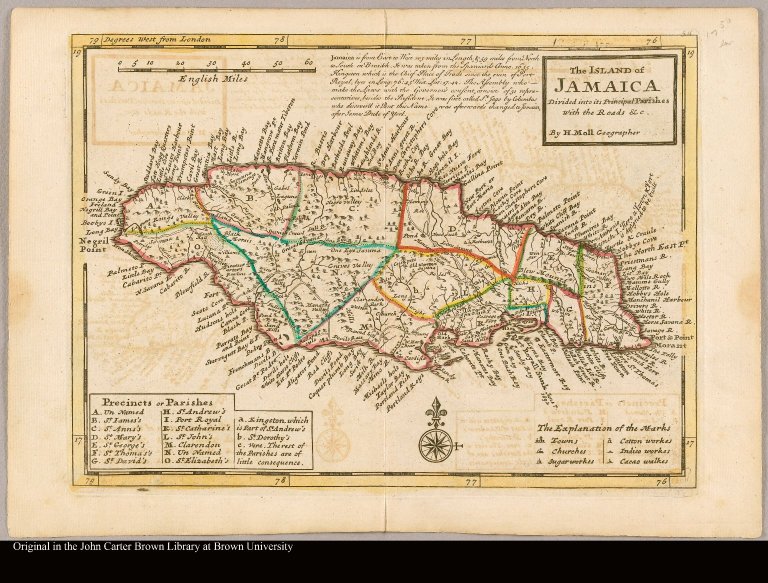
Map title:
The island of Jamaica divided into its principal parishes with the roads &c. by H. Moll, Geographer
Place of Publication:
London
Publication date:
[1763]
Map size height:
20 cm.
Map size width:
28 cm.
Item description:
Engraved map, colored
Geographical description:
Map of Jamaica divided into parishes. Includes towns and churches, as well as sugar, cotton, indigo, and cacao works. Key to "precincts or parishes" at lower left; explanation of symbols at lower right. Engraved commentary on history of Jamaica, a later addition, added at upper center. "56" engraved at top right corner. Relief shown pictorially.
Cartobibliographic notes:
From: H. Moll, Atlas minor (London, J. & C. Bowles, 1763)
References:
Phillips, Atlases, 635, no. 56
Geographic Area:
Caribbean
Normalized date:
1763
LC bibliographic number:
b54056895
Creator:
Moll, Herman, d. 1732
The island of Jamaica divided into its principal parishes with the roads &c. by H. Moll, G...