COLLECTION NAME:
JCB Map Collection
Record
Accession Number:
C-6625
File Name:
C-6625-000
Call number:
Cabinet Ca757 /3
Map title:
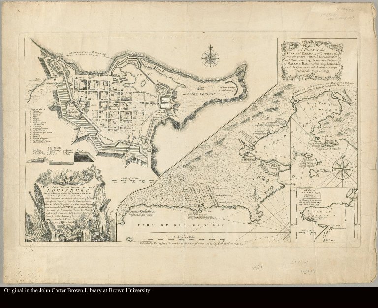
A plan of the city, and fortifications, of Louisburg from a survey made by Richard Gridley, Lieut. Coll. of the train of artillery in 1745
Place of Publication:
London
Publisher:
Published by Thos. Jefferys, geographer to the Prince of Wales at Charing Cross
Publication date:
1757
Map size height:
38 cm.
Map size width:
62 cm.
Item description:
Engraved map
Geographical description:
Plan of Louisbourg, Nova Scotia, Canada. Includes text, index to fortification, "The profile," and insets of "A plan of the city and harbour of Louisburg ... during the siege in 1745" and "A map of Gabarus Bay, adjoyning to Louisburg."
Cartobibliographic notes:
Revised copy of A plan of the city and fortress of Louisbourg ... Boston [1746].
References:
Phillips, Maps:364; Stevens & Tree, no. 27(a)
Geographic Area:
North America
Historical notes:
The map was originally published soon after the siege of Louisbourg, 1745, and was here republished during the French and Indian War in North America.
Normalized date:
1757
LC bibliographic number:
53432502
Creator:
Jefferys, Thomas, d. 1771
A plan of the city, and fortifications, of Louisburg from a survey made by Richard Gridley...