COLLECTION NAME:
JCB Map Collection
mediaCollectionId
JCBMAPS~1~1
JCB Map Collection
Collection
true
Accession Number:
32912
accession_number
32912
Accession Number
false
File Name:
32912-1
file_name
32912-1
File Name
false
Call number:
D778 H974t (copy 1)
call_number
D778 H974t (copy 1)
Call number
false
Map title:
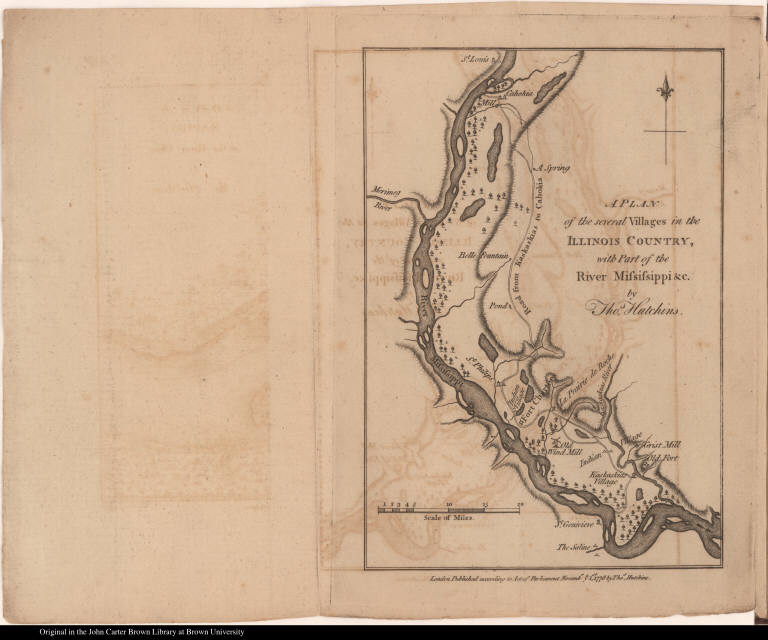
A plan of the several Villages in the Illinois Country, with Part of the River Mississippi &c.
map_title
A plan of the several Villages in the Illinois Country, with Part of the River Mississippi &c.
Map title
false
Place of Publication:
London
place_of_publication
London
Place of Publication
false
Publisher:
Thos. Hutchins
publisher
Thos. Hutchins
Publisher
false
Publication date:
1778
publication_date
1778
Publication date
false
Map size height:
18.3 cm.
map_size_height
18.3 cm.
Map size height
false
Map size width:
12.5 cm.
map_size_width
12.5 cm.
Map size width
false
Item description:
fold-out engraved map; preceding title page
item_description
fold-out engraved map; preceding title page
Item description
false
Geographical description:
Map of a section of the Mississippi River, including the Kaskaskias village, Fort Chartres [Charters], Saint Louis, other Indians villages, an old windmill, grist mill, and fort. Also includes the road from Kaskaskias to Cahokia. Cartographic elements include scale, compass rose, and some topographical details.
geographical_description
Map of a section of the Mississippi River, including the Kaskaskias village, Fort Chartres [Charters], Saint Louis, other Indians villages, an old windmill, grist mill, and fort. Also includes the road from Kaskaskias to Cahokia. Cartographic elements include scale, compass rose, and some topographical details.
Geographical description
false
Source author:
Hutchins, Thomas, 1730-1789
source_author
Hutchins, Thomas, 1730-1789
Source author
false
Source title:
A topographical description of Virginia, Pennsylvania, Maryland, and North Carolina, comprehending the rivers Ohio, Kenhawa, Sioto, Cherokee, Wabash, Illinois, Missisippi [sic], &c. ...
source_title
A topographical description of Virginia, Pennsylvania, Maryland, and North Carolina, comprehending the rivers Ohio, Kenhawa, Sioto, Cherokee, Wabash, Illinois, Missisippi [sic], &c. ...
Source title
false
Source place:
London : printed for the author, and sold by J. Almon, 1778
source_place
London : printed for the author, and sold by J. Almon, 1778
Source place
false
Geographic Area:
North America
geographic_area
North America
Geographic Area
false
Historical notes:
Commissioned as an ensign in the British Army in 1762, Hutchins was transferred to Fort Cavendish (formerly the French Fort de Chartres), about 45 miles downstream of present-day Saint Louis. His skills as a surveyor and tribal negotiator and his mathematical ability meant that he was often assigned the duties of mapping supply routes and recording strategic features in the opening North American frontier.
historical_notes
Commissioned as an ensign in the British Army in 1762, Hutchins was transferred to Fort Cavendish (formerly the French Fort de Chartres), about 45 miles downstream of present-day Saint Louis. His skills as a surveyor and tribal negotiator and his mathematical ability meant that he was often assigned the duties of mapping supply routes and recording strategic features in the opening North American frontier.
Historical notes
false
Normalized date:
1778
normalized_date
1778
Normalized date
false
Creator:
Thomas Hutchins
creator
Thomas Hutchins
Creator
false