COLLECTION NAME:
JCB Map Collection
Record
Accession Number:
05684
File Name:
05684-1
Call number:
D824 B915
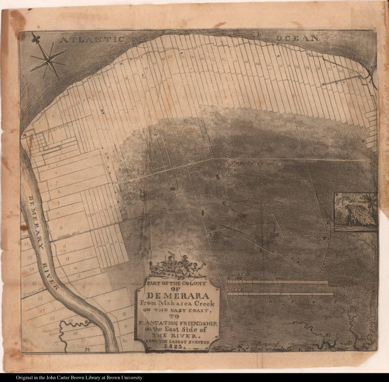
Map title:
Part of the Colony of Demerara From Mahaica Creek on the East Coast, to Plantation Friendship, ... 1823
Place of Publication:
[Demerara]
Publisher:
[A. Stevenson]
Publication date:
1823
Map size height:
20 cm.
Map size width:
22.2 cm.
Item description:
fold-out engraved map; frontispiece
Geographical description:
Map of the colony of Demerara. Cartographic elements include compass rose, scales in miles and roods, locations of canals, river, and plantations. Items are lettered and numbered for identification in Description of the Plates at end of book. Small crosses mark the places where slaves' heads or bodies were displayed.
Source author:
Bryant, Joshua
Source title:
Account of an insurrection of the negro slaves in the colony of Demerara, which broke out on the 18th of August, 1823.
Source place:
Demarara : A. Stevenson, 1824
Geographic Area:
South America
Historical notes:
In August 1823, the enslaved Black people of Demerara met at Mahaica to plan a strike. The slave, Quamina, tried to keep the uprising peaceful. Advice was sought from the local Anglican priest, and considerable discussion took place among slaves, owners, priest, and the government, but the planters and governor felt threatened, and the rebellion was quickly put down by soldiers. Present-day Demerara-Mahaica in Guyana contains Georgetown.
Normalized date:
1823
Creator:
Joshua Bryant
Part of the Colony of Demerara From Mahaica Creek on the East Coast, to Plantation Friends...