COLLECTION NAME:
JCB Map Collection
Record
Accession Number:
36186
File Name:
36186-1
Call number:
Z M726 1709/1 / 3-SIZE
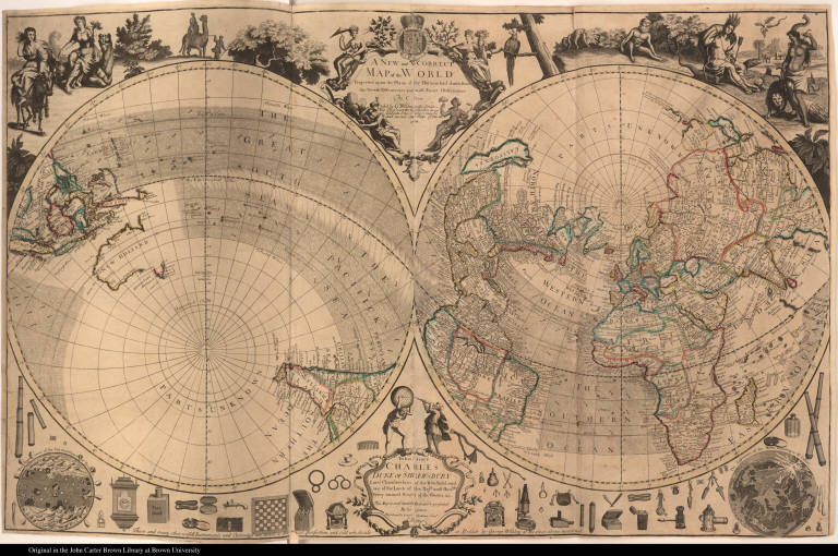
Map title:
A New and Correct Map of the World Projected upon the Plane of the Horizon laid down from the Newest Discoveries and most Exact Observations
Place of Publication:
[London]
Publisher:
Sold by G. Willdey at the Great-Toy Shop ... in Ludgate Street ...
Publication date:
1714
Map size height:
62.8 cm.
Map size width:
99.4 cm.
Item description:
engraving, hand coloring
Geographical description:
Map of the world in two hemispheres showing both the Arctic and Antarctic poles, showing California as an island, and most of the northwest of North America blank. Cartographic elements include sea banks or shoals, lines of latitude and longitude, locations of rivers and native settlements. Decorative elements include images of items such as telescopes, silverware, globes, pistols, clocks, snuff, scissors, armillary sphere, sold by George Willdey, as well as allegorical figures of the four parts of the world including a native American woman wearing a feathered headdress, seated on an alligator. Also includes bird or parrot, royal coat of arms of England, diagram of the moon (according to Giovanni Dominico Cassini) and sun (according to Athanasius Kircher), and monkeys.
Geographic Area:
World
Historical notes:
An early example of product placement, this map was clearly meant to advertise other merchandise at the mapmaker's shop. Willdey (fl.1707-1737) made globes, scientific instruments, cutlery, toys, spectacles, and other useful objects at his shop, the Great Toy Shop in Ludgate, in addition to issuing large format decorative maps.
Normalized date:
1714
Creator:
H. Terasson
Creator:
Charles Price
A New and Correct Map of the World Projected upon the Plane of the Horizon laid down from ...