COLLECTION NAME:
JCB Map Collection
Record
Accession Number:
0899
File Name:
0899-3
Call number:
D769 K74h / 1-SIZE
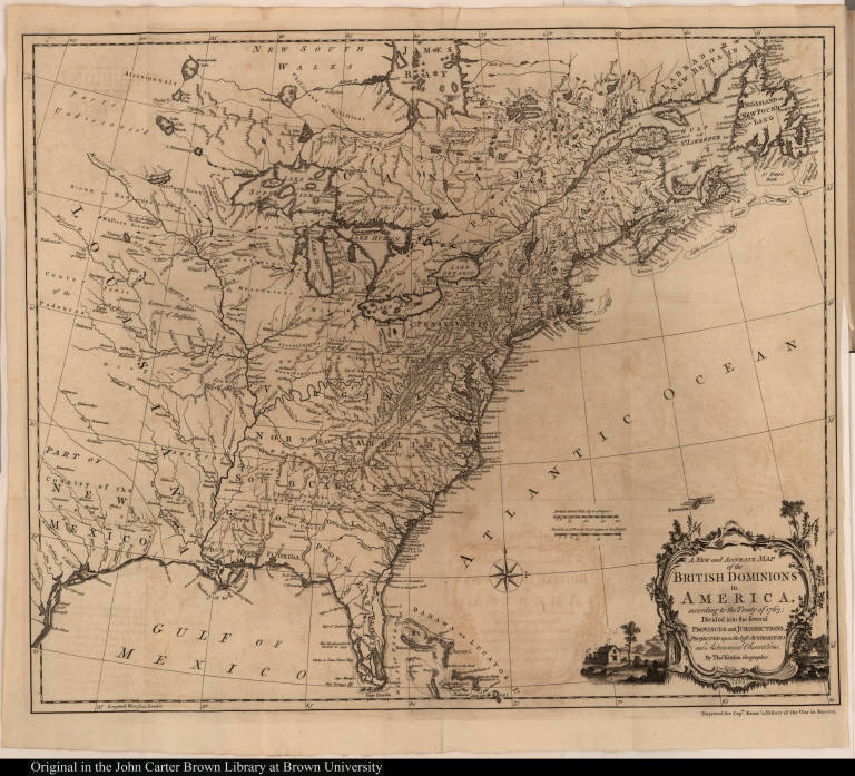
Map title:
A New and Accurate Map of the British Dominions in America, according to the Treaty of 1763; ...
Place of Publication:
[London]
Publisher:
[W. Johnston ... J. Dodsley]
Publication date:
[1769]
Map size height:
52.4 cm.
Map size width:
62.5 cm.
Item description:
fold-out engraved map; vol. 1, preceding p. 1
Geographical description:
Map of North America from Hudson Bay to Florida with the area west of the Mississippi River labeled "undiscovered." Cartographic elements include lines of latitude and longitude, names of bodies of water, compass rose, scales, locations of native American tribes, names of towns and settlements, and sea banks or shoals. Cartouche includes landscape, dwelling, and barrels.
Source author:
Knox, John, d. 1778
Source title:
An historical journal of the campaigns in North-America, for the years 1757, 1758, 1759, and 1760 ... Vol. I
Source place:
London : printed for the author; and sold by W. Johnston; and J. Dodsley, 1769
References:
McCorkle, B.B. New England in Early Printed Maps, 766.1
Geographic Area:
North America
Normalized date:
1769
Creator:
Thomas Kitchin
A New and Accurate Map of the British Dominions in America, according to the Treaty of 176...