COLLECTION NAME:
JCB Map Collection
Record
Accession Number:
32354
File Name:
32354-2
Call number:
D747 B691w
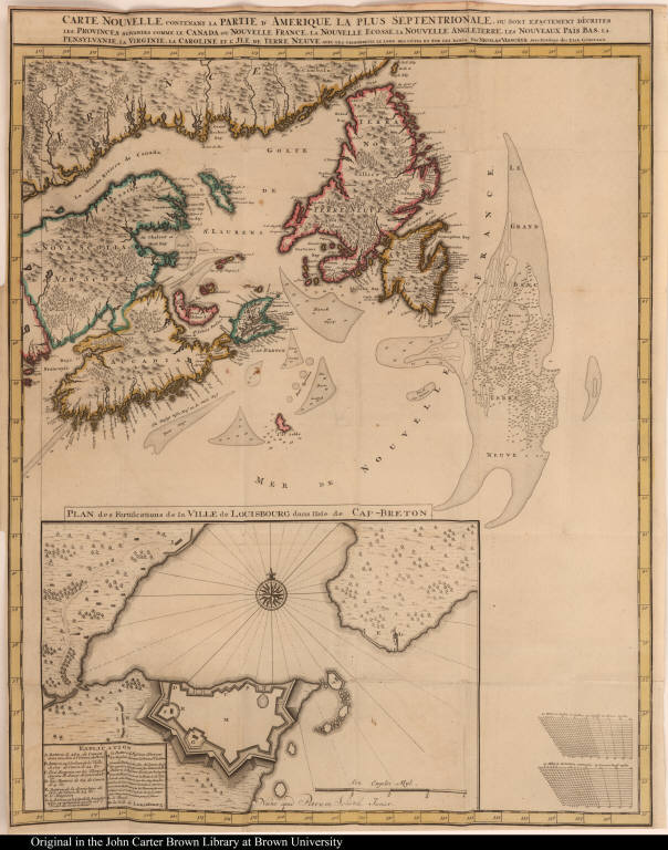
Map title:
Carte Nouvelle contenant la Partie d'Amerique la plus Septentrionale ...
Place of Publication:
[Leipzig]
Publisher:
Nunc apud Petrum Schenk Junior [Peter Schenk]
Publication date:
[1747]
Map size height:
59.1 cm.
Map size width:
46.9 cm.
Item description:
fold-out engraved map; preceding title page, hand coloring
Geographical description:
Chart of the mouth of the Saint Lawrence River including Nova Scotia, Newfoundland, Cape Breton and the Grand Banks. Cartographic elements include degrees of latitude and longitude, some topographical details, soundings, sea banks or shoals, and compass rose. Includes an inset map of Louisbourg harbor and fortifications which are lettered for identification in key at bottom.
Source author:
Bollan, William, d. 1776
Source title:
[Importance and advantage of Cape Breton. German] Die Wichtigkeit und Vortheil des Kap-Breton ...
Source place:
Leipzig : bey Peter Schenken im hohmannischen hofe, 1747
Cartobibliographic notes:
This Visscher map was first printed in 1689; this is the last state and includes the inset map of the fortifications at Louisbourg.
References:
McCorkle, B.B. New England in Early Printed Maps, 689.8
Geographic Area:
North America
Normalized date:
1747
Creator:
Nicolaes Visscher
Carte Nouvelle contenant la Partie d'Amerique la plus Septentrionale ...