COLLECTION NAME:
JCB Map Collection
Record
Accession Number:
07376
File Name:
07376-13
Call number:
B728 H564h / 2-SIZE
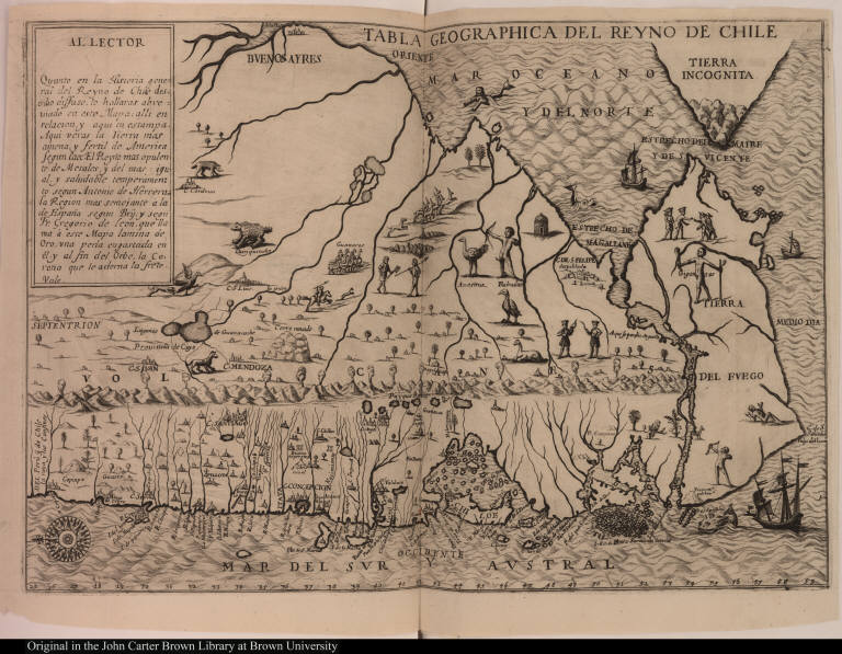
Map title:
Tabla geographica del reyno de Chile
Place of Publication:
[Antwerp]
Publisher:
[Juan Bautista Verdussen]
Publication date:
[1728]
Map size height:
30.5 cm.
Map size width:
43.8 cm. [both pages]
Item description:
etching, engraved map, vol.. 4, following p. 334
Geographical description:
Map of the coastline of Chile. Cartographic elements include sea banks or shoals, compass rose, location of rivers and settlements. Decorative elements include lion, llamas or guanacos, parrot, penguin [?], rheas, armadillo, sea monsters, mermaid, ships, native American with a tail, a Patagonian giant, stag or deer chased by a dog, volcanoes, native Americans with bows and arrows, hunting birds, and settlements.
Source author:
Herrera y Tordesillas, Antonio de, d. 1625
Source title:
[Historia general de los hechos de los castellanos] Historia general de las Indias Ocidentales ... Tomo quarto
Source place:
En Amberes : Por Juan Bautista Verdussen, mercader de libros. M.D.CC.XXVIII
Cartobibliographic notes:
This image is derived from the map in Alonso de Ovalle, Historica relacion del reyno de Chile, Rome, 1646.
Geographic Area:
South America
Normalized date:
1728
Tabla geographica del reyno de Chile