COLLECTION NAME:
JCB Map Collection
Record
Accession Number:
32507
File Name:
32507-1
Call number:
Z P975 1507 / 2-SIZE (copy 1)
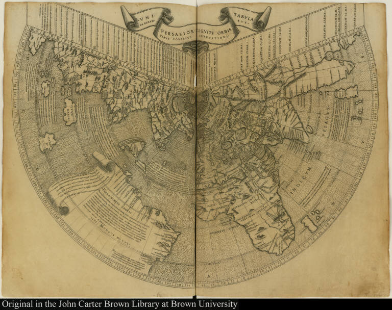
Map title:
Universalior cogniti orbis tabula ex recentibus confecta observationibus
Place of Publication:
[Rome]
Publisher:
[Bernardinus Venetus de Vitalibus]
Publication date:
[1508]
Map size height:
39.8 cm.
Map size width:
53.7 cm. [both pages]
Item description:
woodcut
Geographical description:
World map drawn on a conical projection showing South America as a separate landmass (Brazil, "Terra Sancte Crucis"), Caribbean islands (Spagnola or Hispaniola, Cuba, and others), and Greenland and Newfoundland (Terra Nova) as part of China. Cartographic elements include lines of latitude and longitude, some topographical details, and location of rivers.
Source author:
Ptolemy, fl. 2nd cent.
Source title:
Geographia
Source place:
Romae : Nouiter impressum per Bernardinu[m] Venetu[m] de Vitalibus, Die VIII. Septe[m]br. M.D.VII
References:
Shirley, R.W. Mapping of the World, 25; Burden, P.D. Mapping of North America p. xxiii; Swan, B.F. "Ruysch Map of the World," Papers of the Bibliographical Society of America, 1951; John Carter Brown Library, Annual Report, 1959, p. 33-37
Geographic Area:
World
Historical notes:
Editors of Ptolemy during the sixteenth century attempted to reconcile his work to the discoveries of lands unknown to the second century geographer. This 1507 edition of Ptolemy produced in Rome includes the engraved map made by Johannes Ruysch. Ruysch is presumed to have himself made a voyage in about 1502 to 1504 to the coast of present-day Labrador and then north along the coast of Greenland, and his depiction of that land may be based on his experience. This map is the first printed map to be made by someone who explored the New World.The depiction of Caribbean islands and Brazil is based on Portuguese explorations.This map is the fifth state of the plate.
Normalized date:
1508
Creator:
Johann Ruysch
Universalior cogniti orbis tabula ex recentibus confecta observationibus