COLLECTION NAME:
JCB Map Collection
Record
Accession Number:
32173
File Name:
32173
Call number:
Cabinet A590 / 1
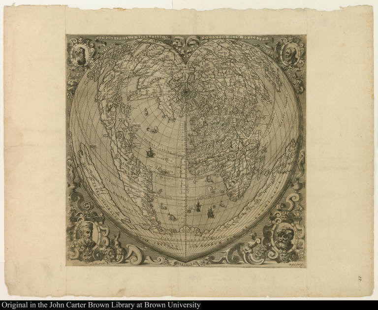
Map title:
Cosmographia universalis ab Orontio olim descripta
Place of Publication:
[Venice]
Publication date:
[ca. 1590]
Map size height:
43.3 cm.
Map size width:
45 cm.
Item description:
engraving
Geographical description:
Map (heart-shaped or cordiform) of the world including part of the coast of North and South America and the islands of Isabella (present-day Cuba) and Spagnolla or Hispaniola (present-day Dominican Republic and Haiti). Cartographic elements include degrees of latitude and longitude (based on Ferro meridian), some topographical details. Decorative elements include ships, sea monsters, and four portrait medallions of Ptolemy, Oronce Finé, Pomponius Mela, and Strabo.
Cartobibliographic notes:
The cordiform map of Oronce Finé was first published in 1539; its chief interest from an American point of view is the form of the west coast of South America drawn while that coast was still being explored and in the way in which North America is connected to Asia. A better-known reprint of the map was published in 1566. This map is a reduced copy of that map and differs from it primarily in the decorations and portraits along the border.
References:
Shirley, R.W. Mapping of the World, 152; John Carter Brown Library, Annual Reports, 1958, p. 55
Geographic Area:
World
Normalized date:
1590
Creator:
Rafael faitel
Creator:
Giacomo Franco
Cosmographia universalis ab Orontio olim descripta