COLLECTION NAME:
JCB Map Collection
Record
Accession Number:
6161
File Name:
6161
Call number:
Cabinet Cc776 9.1
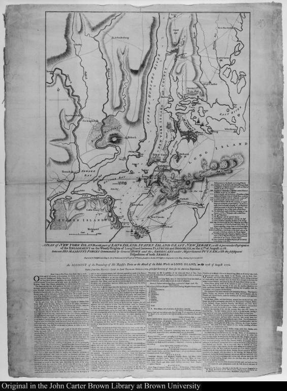
Map title:
A Plan of New York Island with part of Long Island, Staten Island & East New Jersey, with a particular Description of the Engagement on Woody Heights of Long Island...
Place of Publication:
London
Publisher:
William Faden
Publication date:
Oct. 19th. 1776
Map size height:
47.3 cm.
Map size width:
42.1 cm.
Item description:
engraving
Geographical description:
Plan of New York City and description of the battle of Woody Heights. Cartographic elements include topographical details, location of roads and settlements, soundings, movements of troops and ships.
References:
Phelps Stokes, I.N. Iconography of Manhattan, I, 353-355; Nebenzahl, K. British battle plans, no. 107; Phillips, P.L. Atlases, 1207, no. [18]
Geographic Area:
North America
Historical notes:
The Battle of Brooklyn was initially won by the British when their far greater number of troops under General Howe landed in Brooklyn on August 27, 1776. General Washington, aware of a potential massacre, withdrew his troops from their fortified position on Woody Heights to Manhattan, thereby saving many lives. By September 15, the British had won the city. This map was first issued less than five weeks after this major battle to illustrate the victory to the British public. It was then updated five times to describe the progress of the British campaign.
Normalized date:
1776
Creator:
William Faden
A Plan of New York Island with part of Long Island, Staten Island & East New Jersey, with ...