COLLECTION NAME:
JCB Map Collection
Record
Accession Number:
30537a
File Name:
30537a
Call number:
Cabinet Jf600 /1
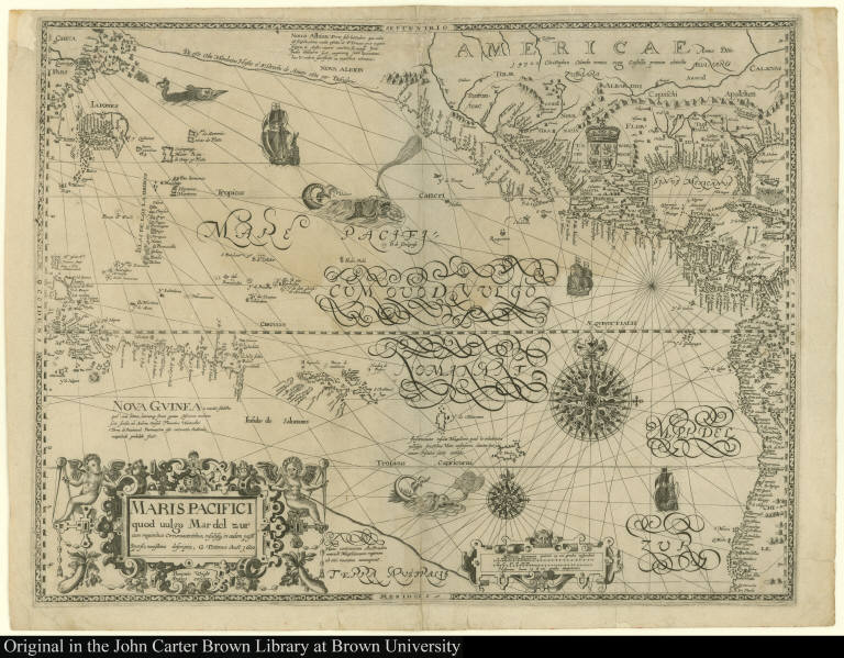
Map title:
Maris pacifici quod uulgo Mar del zur cum regionibus Circumiacentibus ... novissima descriptio
Place of Publication:
[Amsterdam]
Publication date:
1600
Map size height:
40.4 cm.
Map size width:
52.8 cm.
Item description:
engraving
Geographical description:
Chart of the Pacific Ocean showing much of North America and the west coast of South America. California is shown as a peninsula, the Appalachian Mountains are included, and the northwest coast of North America is shown as undiscovered. Cartographic elements include rhumb lines, compass roses, topographical details, sea banks, and scale. Decorative elements include ships, sea monsters, Spanish royal coat of arms of Castile and Leon. Decorative cartouche includes angels with navigational tools, dividers, and angles.
Cartobibliographic notes:
The extent of the map is derived from the 1589 Abraham Ortelius map of the same title. cartographicly, the map draws on other sources, possibly Spanish and Portuguese charts of the period. A manuscript chart by Tatton exists in Florence which is similar. This map is extremely rare and survives in only three known examples.
References:
Burden, P.D. Mapping of North America, 136; Wagner, H.R. Cartography of the northwest coast of America, vol. I, p. 84-86; John Carter Brown Library, Annual Report, 1949, p. 7-130
Geographic Area:
Western hemisphere
Normalized date:
1600
Creator:
Benjamin Wright
Creator:
Gabriel Tatton
Maris pacifici quod uulgo Mar del zur cum regionibus Circumiacentibus ... novissima descri...