COLLECTION NAME:
JCB Map Collection
Record
Accession Number:
C-0026
File Name:
C-0026
Call number:
Cabinet C61 Ch677
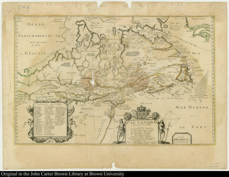
Map title:
Le Canada faict par le Sr. de Champlain où sont La Nouvelle France, La Nouvelle Angleterre, La Nouvelle Holande, La Nouvelle Svede, La Virginie &c.
Place of Publication:
A Paris
Publisher:
En l'Isle du Palais, au coin de la rue de Harlay
Publication date:
1677
Map size height:
34.8 cm.
Map size width:
54.2 cm.
Item description:
engraving, hand coloring
Geographical description:
Map of New France. Cartographic elements include degrees of latitude, sea banks, and scales. Also gives the route of the Northwest Passage. Decorative cartouche is flanked by two native Americans holding a bow and spear. Also includes the royal coat of arms of France. Items in the image are numbered for identification in a key at bottom left.
Cartobibliographic notes:
This map was originally engraved for Samuel de Champlain. A "proof" issue of the plate with the imprint of Champlain was made in circa 1616 (the only known copy of this issue is held by the John Carter Brown Library). Later Pierre Du Val acquired the copperplate of the map, finished it, and published it in 1653. This map is a later state of the plate published in 1677.
References:
McCorkle, B.B. New England in Early Printed Maps, 677.1; Burden, P.D. Mapping of North America, 309
Geographic Area:
North America
Normalized date:
1677
Creator:
Pierre Duval
Le Canada faict par le Sr. de Champlain où sont La Nouvelle France, La Nouvelle Angleterre...