COLLECTION NAME:
JCB Map Collection
Record
Accession Number:
C-0090-000
File Name:
C-0090-000
Call number:
Cabinet A546 /1
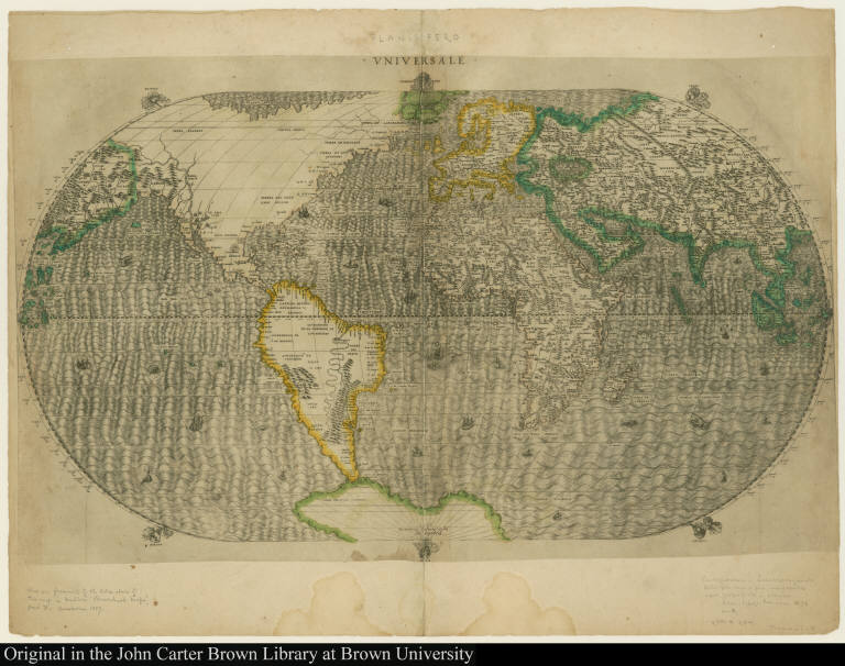
Map title:
Vniversale
Place of Publication:
[Venice]
Publication date:
[1546]
Map size height:
29.3 cm.
Map size width:
53.1 cm.
Item description:
engraving, hand coloring
Geographical description:
World map on oval projection. North and South America are shown with North America as part of China. Cartographic elements include lines of latitude and longitude, location of some rivers and settlements (Temitistan, or Tenochtitlán, is especially noted, as are the seven cities of Coronado), some topograpical details, and six windheads. Decorative elements include ships and sea monsters.
Cartobibliographic notes:
Apparently proof state before addition of cloud border, author, imprint, and without word "Amazon" in South America. The map is pasted on another paper labeled "Planisfero." Made by Giacomo Gastaldi, the most influential Venetian map publisher of the 16th century, this map was the prototype of a series of later world maps, including Ortelius's world map in his atlas of 1570.
References:
Shirley, R.W. Mapping of the world, 85, plate 72; John Carter Brown Library, Annual Report, 1957, p. 25; Tooley, R.V. "Maps in Italian atlases," Imago Mundi III: 3; British Museum Printed Maps 15/523.
Geographic Area:
World
Normalized date:
1546
Creator:
Giacomo Gastaldi
Vniversale