COLLECTION NAME:
JCB Map Collection
Record
Accession Number:
8189
File Name:
8189-12
Call number:
Cabinet Blathwayt 12
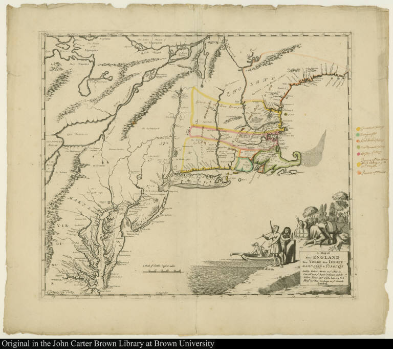
Map title:
A Map of New England New Yorke New Iersey Mary-Land & Virginia
Place of Publication:
London
Publisher:
Sould by Robert Morden at ye Atlas ... and by William Berry at ye Globe ...
Publication date:
[1676]
Map size height:
44.6 cm.
Map size width:
52.6 cm.
Item description:
engraving, hand coloring
Geographical description:
Map of of northeastern North America, including the coast from Maine to Virginia. Also includes some of the Great Lakes and the St. Lawrence River. Cartographic elements include some topographical details, degrees of latitude and longitude, location of native American tribes, rivers, sea banks, and some settlements, and borders of colonies. Decorative cartouche includes native Americans hunting, fishing, and pounding grain. Also includes tobacco pipe, rolls of tobacco, deer or stag, canoe or boat, bow, and feathered headdress. Boundaries of colonies are identified in manuscript key in right border.
Cartobibliographic notes:
This map and Map 11 in the Blathwayt Atlas are impressions from the same engraved copperplate but on different material. Map 11 was printed on vellum and does not include colors or color key. These maps published by Morden and Berry apparently have no direct derivatives and are compiled from several sources--the northern section is similar to the map by John Seller [both his map and this map include names connected with King Philip's War, such as Mounthope," "King Philip's Country," and "Spaw Sachem" [or Squaw sachem, i.e., Weetamoe, King Philip's sister-in-law], the New Jersey section is based upon the contemporary Dutch maps of the Jansson-Visscher series, and the southern section is a reduced and simplified version of Augustine Herrman's Virginia and Maryland.The Blathwayt Atlas is a collection of 48 maps assembled between 1680 and 1685 as a reference atlas for the Office of Trade and Plantations, compiled by William Blathwayt, Secretary to the Lords of Trade and Plantations.
References:
Black, J.D., ed. Blathwayt Atlas, vol. II, p. 82-87
Geographic Area:
North America
Normalized date:
1676
Creator:
Gregory King
A Map of New England New Yorke New Iersey Mary-Land & Virginia