COLLECTION NAME:
JCB Map Collection
Record
Accession Number:
8995
File Name:
8995-1
Call number:
Cabinet GL740 / 1
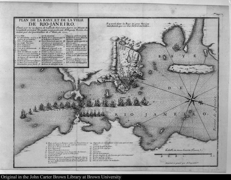
Map title:
Plan de la baye, et de la ville de Rio-Janeiro, ...
Place of Publication:
[Paris?]
Publisher:
[P.-F. Godart de Beauchamps]
Publication date:
[1740]
Map size height:
22.5 cm.
Map size width:
30.7 cm.
Item description:
etching, engraving
Geographical description:
Map of the city of Rio de Janeiro and chart of the bay of Guanabara. Includes locations of forts, islands, magazines, important houses, batteries, locations of battles and fleets, a scale in French leagues, and a compass rose. Items are lettered and numbered for identification in a key within the image.
Geographic Area:
SouthAmerica
Historical notes:
This map was published in René Duguay-Trouin, Mémoires, Paris?, 1740. Map is here held separately.Du Guay-Trouin was a Breton pirate from St. Malo who was so successful in attacking British ships that he was made a French naval commander. Text states that he sacked the city of Rio de Janeiro between 11 September and 4 November, 1711.
Normalized date:
1740
Creator:
A. Coquart
Plan de la baye, et de la ville de Rio-Janeiro, ...