Detail View: JCB Map Collection: The theatre of war in North America with the roads, and tables, of the superficial contents, distances, & ca. by an American
|
Accession Number:
|
31293
|
|
File Name:
|
31293-000
|
|
Call number:
|
Cabinet C776 2
|
|
Map title:
|
The theatre of war in North America with the roads, and tables, of the superficial contents, distances, & ca. by an American
|
|
Publication date:
|
20th November 1776
|
|
Map size height:
|
74 cm.
|
|
Map size width:
|
52 cm.
|
|
Item description:
|
Engraved map, colored
|
|
Geographical description:
|
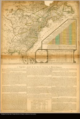
Map of North America during the Revolutionary War. Below map is letterpress entitled: A compendious account of the British colonies in North America. Same setting of type as text on The theatre of war in North America, with the roads and a table of the distances, London, March , 1776. Lower right corner of map includes Evan's polymetric table of America, with distances, and Thomas Templeman's survey of the size and area of the individual colonies.
|
|
Cartobibliographic notes:
|
2nd edition, 1st state, with entirely new plate from 1st edition that now shows all of Florida peninsula with title in cartouche.
|
|
References:
|
Stevens & Tree, no. 59(a); WLCL 2:443
|
|
Geographic Area:
|
North America
|
|
Scale 1:
|
7,500,000
|
|
Normalized date:
|
1776
|
|
LC bibliographic number:
|
b53431832
|
|
Creator:
|
Jefferys, Thomas,d. 1771
|