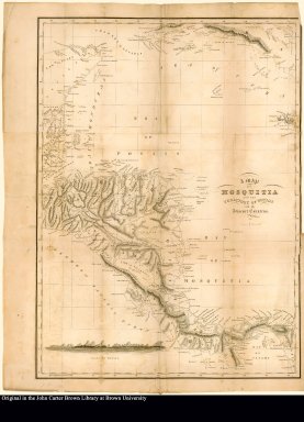
Detail View: JCB Map Collection: A map of Mosquitia and the territory of Poyais with the Adjacent Countries,

|
Accession Number:
|
79-17
|
|
File Name:
|
79-17-003
|
|
Call number:
|
D822 S897s
|
|
Map title:
|
A map of Mosquitia and the territory of Poyais with the Adjacent Countries,
|
|
Place of Publication:
|
Edinburgh
|
|
Publisher:
|
Sold by William Blackwood and T. Caddell, Strand, London
|
|
Publication date:
|
1822
|
|
Map size height:
|
51 cm.
|
|
Map size width:
|
42 cm.
|
|
Item description:
|
fold-out engraved map,
|
|
Geographical description:
|
Map of Mosquitia or present-day Honduras, Mexico [Yucatan], and Panama. Also includes a profile of the "coast of Poyais."
|
|
Source author:
|
Strangeways, Thomas
|
|
Source title:
|
Sketch of the Mosquito shore, including the territory of Poyais, descriptive of the country; with some information as to its productions, the best mode of culture, &c. chiefly intended for the use of settlers
|
|
Source place:
|
Edinburgh: Sold by William Blackwood; Edinburgh: and T. Caddell, Strand, London, 1822
|
|
Cartobibliographic notes:
|
Colophon reads: Leith.--Printed by Wm. Reid.
|
|
References:
|
Sinclair, D. The land that never was
|
|
Geographic Area:
|
North America
|
|
Historical notes:
|
Founded by Gregor MacGregor, the fictitious state of Poyais was promoted in the 1820s as a means of raising fraudulent loans. He had obtained a land grant from the Moskito king in what would now be Honduras, and on this basis created an entirely fictitious state with himself as ruler. To bolster his claims, he provided detailed accounts not only of the country's geography and economic resources but of its state coat of arms, military uniforms etc., including the national flag, which was a green St. George's Cross on a white background. He went so far as to send out colonists (most of whom never returned) and this flag was actually hoisted on the ship which carried them.
|
|
Normalized date:
|
1822
|
|
LC bibliographic number:
|
b51790178
|
|
Creator:
|
Lizars, W. H. (William Home), 1788-1859
|