Detail View: JCB Map Collection: Achaia quae et Hellas hodie Livadia
|
Accession Number:
|
11575
|
|
File Name:
|
11575-030
|
|
Call number:
|
F697 C649i2
|
|
Map title:
|
Achaia quae et Hellas hodie Livadia
|
|
Place of Publication:
|
Amsterdam and London
|
|
Publisher:
|
Typis Joannis Wolters
|
|
Publication date:
|
M DC XCVII.
|
|
Map size height:
|
24.5 cm.
|
|
Map size width:
|
27 cm.
|
|
Item description:
|
fold-out engraved map, plate 29, following p. 336
|
|
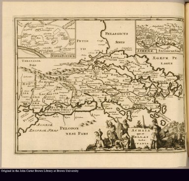
Geographical description:
|
Map of present-day Greece from the gulf of Corinth to the Malian Gulf. Includes an inset map of Thebae Boeticae [Thebes in Boeotia] and Athenae [Athens]. Locations are given their Roman place names. Decorative cartouche includes victorious soldiers beating down kneeling subjects. Also includes swords, shields, and other military equipment.
|
|
Source author:
|
Clüver, Philipp, 1580-1622
|
|
Source title:
|
Philippi Cluverii Introductio in universam geographiam tam veterem quam novam tabulis geographicis XLVI. ac notis olim ornata à Johanne Bunone, jam verô locupletata additamentis & annotationibus Joh. Frid. Hekelii & Joh. Reiskii
|
|
Source place:
|
Amstelaedami: Typis Joannis Wolters. Londini, postant apud Sam. Smith & Benj. Walford, in coemetario D. Pauli,. M DC XCVII.
|
|
Cartobibliographic notes:
|
Engraved, added title page reads: Philippi Cluverii Introductionis in universam geographiam cum notis I. Bunonis Hekelii et Reiskii Lib. VI. Veduntur Amsteldaedami. Apud Joannem Wolters. A[nn]o 1697. This copy has "typis" correctly spelled in imprint.
|
|
Geographic Area:
|
Europe
|
|
Normalized date:
|
1697
|
|
LC bibliographic number:
|
b72151432
|