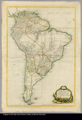
Detail View: JCB Map Collection: Amérique meridionale par M. Moithey, ing. geog. du Roi, et professeur de mathématiques de M.M. les pages de S. A. S. Monseigneur le prince de Conty
|
Accession Number:
|
C-7709
|
|
File Name:
|
C-7709-000
|
|
Call number:
|
Cabinet G785 MoM
|
|
Map title:
|
Amérique meridionale par M. Moithey, ing. geog. du Roi, et professeur de mathématiques de M.M. les pages de S. A. S. Monseigneur le prince de Conty
|
|
Place of Publication:
|
Paris
|
|
Publisher:
|
chez le Sr. Moithey rue de la harpe la porte cochère no. 109 et chez Crépy rue S. Jacques près celle de la parcheminerie
|
|
Publication date:
|
1785
|
|
Map size height:
|
81 cm.
|
|
Map size width:
|
58 cm.
|
|
Item description:
|
Engraved map, colored
|
|
Geographical description:
|
Map of South American including highly developed river systems: only rudimentary marking of mountain ranges. Occasional geographico-historical notes and numerous designations of Indian tribal and placenames. Irregular stereographic projection, with Ferro as prime meridian. Title in lower right corner within cartouche of rococo plastermark and foliage, and including Neptune: above it the publication date in a wreath. Signed with engraver's name "Gras."
|
|
Cartobibliographic notes:
|
Largely based on d'Anville's 3-sheet Amérique méridionale (Paris, 1748).
|
|
References:
|
BMPM 1/516
|
|
Geographic Area:
|
South America
|
|
Scale 1:
|
ca. 11,000,000
|
|
Normalized date:
|
1785
|
|
LC bibliographic number:
|
b54058004
|
|
Creator:
|
Moithey, Maurille Antoine, 1732-ca. 1810
|
|
Creator:
|
Gras
|