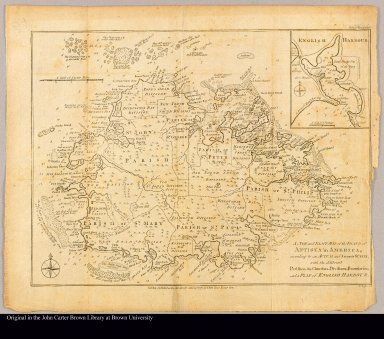
Detail View: JCB Map Collection: A new and exact map of the island of Antigua in America, according to an actual and accurate survey, with the different parishes, the churches, divisions, boundaries and a plan of English Harbour

|
Accession Number:
|
9008-1
|
|
File Name:
|
9008-1-000
|
|
Call number:
|
Cabinet Er749 BaR 782
|
|
Map title:
|
A new and exact map of the island of Antigua in America, according to an actual and accurate survey, with the different parishes, the churches, divisions, boundaries and a plan of English Harbour
|
|
Place of Publication:
|
London
|
|
Publisher:
|
J. Bew, Pater Noster Row
|
|
Publication date:
|
Janr. 31th, 1782
|
|
Map size height:
|
28 cm.
|
|
Map size width:
|
37 cm.
|
|
Item description:
|
Engraved map
|
|
Geographical description:
|
Map of the island of Antigua divided into parishes. Includes location of churches, shoals and soundings. Inset at upper right: English Harbour." Jno. Lodge sculp." "Political Mag. Janr. 1782."
|
|
Cartobibliographic notes:
|
Standard reduction of R. Baker's A new and exact map of the island of Antigua ..., London, 1749, from the Political Magazine, January 1782.
|
|
References:
|
MCC 55, "The printed maps of Antigua, ...," no. 43; WLCL 3:26; BMPM 1/635
|
|
Geographic Area:
|
Caribbean
|
|
Normalized date:
|
1782
|
|
LC bibliographic number:
|
b54057152
|
|
Creator:
|
Baker, Robert, surveyor
|
|
Creator:
|
Lodge, John
|