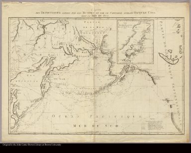
Detail View: JCB Map Collection: Carte des decouvertes faites par les Russes et par le capitaine anglois Jacques Cook dans la Mer du Sud
|
Accession Number:
|
C-6925
|
|
File Name:
|
C-6925-000
|
|
Call number:
|
Cabinet Cl787 WiA
|
|
Map title:
|
Carte des decouvertes faites par les Russes et par le capitaine anglois Jacques Cook dans la Mer du Sud
|
|
Place of Publication:
|
St. Petersburg
|
|
Publication date:
|
[1787]
|
|
Map size height:
|
64 cm.
|
|
Map size width:
|
86 cm.
|
|
Item description:
|
Engraved map
|
|
Geographical description:
|
Map of the northwestern part of North America, including present-day Alaska and Canada, showing the Bering Strait. The tracks of the ship in the respective expeditions of Bering in 1728 and 1741, of Chirikov on his return in 1741-2, of Crenizin in 1768, of Spanberg in 1738, of Walton in 1738, of Schelting in 1741, of Petushkov in 1777, and of Cook in his third voyage in 1778-9, are individually marked. A key to the different lineations employed is at lower right. "Les longitudes se comptent de l'Isle de Fer." Title above the top frame line. At lower left, outside the border, "Composé par Alex. Wilbrecht en 1787." At lower right, similarly, "Gravé et écrit par I. C. Nabholz." Inset at top of map, right of center: Carte des Isles Kichtak et Afognat (off Alaska's southern coast] et des autres adjacentes decouvertes par le Pilote de la Marine Imper[iale] Ismailoff.
|
|
References:
|
Streeter VI, no. 3483 (this copy)
|
|
Geographic Area:
|
North America
|
|
Scale 1:
|
ca. 15,000,000
|
|
Normalized date:
|
1787
|
|
LC bibliographic number:
|
b53976502
|
|
Creator:
|
Wilbrecht, Alexander
|