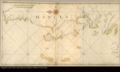
Detail View: JCB Map Collection: [Luzon, Philippine Islands, west coast, with part of Mindoro]
|
Accession Number:
|
C-6611
|
|
File Name:
|
C-6611-000
|
|
Call number:
|
Cabinet Nn72 Lu Ms.
|
|
Map title:
|
[Luzon, Philippine Islands, west coast, with part of Mindoro]
|
|
Place of Publication:
|
Philippines
|
|
Publication date:
|
[ca. 1720]
|
|
Map size height:
|
53 cm.
|
|
Map size width:
|
68 cm.
|
|
Item description:
|
Manuscript map on vellum, colored
|
|
Geographical description:
|
Manuscript map of Luzon, Philippine Islands. Shows west coast of Luzon as far north as Cape Bojeador. Place names in Spanish, with some Portuguese spellings. Some soundings given.
|
|
References:
|
Quirino, p. 89
|
|
Geographic Area:
|
Other
|
|
Normalized date:
|
1720
|
|
LC bibliographic number:
|
54176943
|