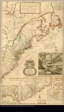
Detail View: JCB Map Collection: A new and exact map of the dominions of the King of Great Britain on ye continent of North America containing Newfoundland, New Scotland, New England, New York, New Jersey, Pensilvania, Maryland, Virginia and Carolina according to the newest and most exact observations by Herman Moll, geographer

|
Accession Number:
|
08719x
|
|
File Name:
|
08719x-000
|
|
Call number:
|
Cabinet Ca726 /1
|
|
Map title:
|
A new and exact map of the dominions of the King of Great Britain on ye continent of North America containing Newfoundland, New Scotland, New England, New York, New Jersey, Pensilvania, Maryland, Virginia and Carolina according to the newest and most exact observations by Herman Moll, geographer
|
|
Place of Publication:
|
London
|
|
Publisher:
|
Sold by H. Moll and by I. King at ye Globe in ye Poultrey near Stocks Market.
|
|
Publication date:
|
1726
|
|
Map size height:
|
101 cm.
|
|
Map size width:
|
61 cm.
|
|
Item description:
|
Engraved map, colored
|
|
Geographical description:
|
Map of North America from Labrador south to South Carolina and west to Lake Huron and Hudson Bay. Includes inset maps; French Louisiana, Carolina coast from Cape Carteret to the Ashapoo River (a continuation of the main map), Charleston, South Carolina, and a map of the known parts of North America. Includes vignette of colony of beavers building a dam below Niagara Falls. Also includes coat of arms of the Honorable Walter Dowglass, governor of the Leeward Islands. Cartographic elements include sea banks or shoals, soundings, lines of longitude and latitude, and compass rose. Insets: The cataract of Niagara--A draught of ye town and harbour of Charles-town--A map of the principal part of North America--A map of the improved part of Carolina with the settlements &c.--[South part of Carolina and the east part of Florida]. At upper right, 21-line note on post-roads. Dedication: "To the Honourable Walter Dowglass Esqr. ... 1715." Prime meridian: London. Relief shown pictorially.
|
|
Cartobibliographic notes:
|
Removed from atlas with binder's title North America. British provinces, no. [24]). Revised state of the plate, imprint altered. The map is known as the Beaver Map. Imprint date from W.P. Cumming's Southeast in early maps, no. 158, C. and Stevens & Tree. This map is state 2 according to McCorkle.
|
|
References:
|
MeCorkle 715.1; Phillips, Atlases 5961, no. [8]; Phillips, Maps:566; Stevens & Tree, no. 55(b); BMPM 10/8
|
|
Geographic Area:
|
North America
|
|
Scale 1:
|
ca. 3,000,000
|
|
Normalized date:
|
1726
|
|
LC bibliographic number:
|
53432150
|
|
Creator:
|
Moll, Herman, d. 1732
|