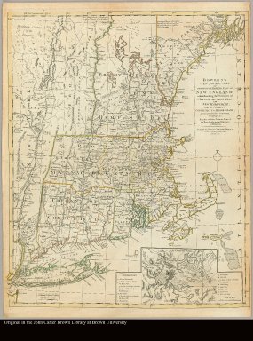
Detail View: JCB Map Collection: Bowles's new pocket map of the most inhabited part of New England comprehending the Provinces of Massachusets Bay and New Hampshire; with the Colonies of Connecticut & Rhode Island divided into their counties, townships, &c. together with an accurate plan of the town, harbour and environs of Boston

|
Accession Number:
|
31287
|
|
File Name:
|
31287-000
|
|
Call number:
|
Cabinet Cb765 /1.4
|
|
Map title:
|
Bowles's new pocket map of the most inhabited part of New England comprehending the Provinces of Massachusets Bay and New Hampshire; with the Colonies of Connecticut & Rhode Island divided into their counties, townships, &c. together with an accurate plan of the town, harbour and environs of Boston
|
|
Place of Publication:
|
London
|
|
Publisher:
|
Printed for the Proprietor Carington Bowles, No. 69 in St Pauls Church Yard
|
|
Publication date:
|
[ca. 1780]
|
|
Map size height:
|
64 cm.
|
|
Map size width:
|
52 cm.
|
|
Item description:
|
Engraved map, colored
|
|
Geographical description:
|
Map of the northeastern part of North America. Inset at lower right: [Plan of Boston Harbor]
|
|
Cartobibliographic notes:
|
Former title: A map of the most inhabited part of New England, London, Bowles [ca. 1765]. Revised state of the plate, extensively reworked. Title and imprint altered. The map is attributed to Braddock Mead, ca. 1685-1757, whose alias was John Green.
|
|
References:
|
Stevens & Tree, no. 32(e); Phillips, Maps:471
|
|
Geographic Area:
|
North America
|
|
Normalized date:
|
1780
|
|
LC bibliographic number:
|
53846886
|
|
Creator:
|
Green, John, d. 1757
|