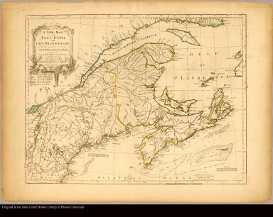
Detail View: JCB Map Collection: A new map of Nova Scotia, and Cape Breton Island with the adjacent parts of New England and Canada, composed from a great number of actual surveys; and other materials regulated by many new astronomical observations of the longitude as well as latitude /|cby Thomas Jefferys, geographer to the King
|
Accession Number:
|
C-8249
|
|
File Name:
|
C-8249-000
|
|
Call number:
|
Cabinet Ca755 /2.2
|
|
Map title:
|
A new map of Nova Scotia, and Cape Breton Island with the adjacent parts of New England and Canada, composed from a great number of actual surveys; and other materials regulated by many new astronomical observations of the longitude as well as latitude /|cby Thomas Jefferys, geographer to the King
|
|
Place of Publication:
|
London
|
|
Publisher:
|
Published ... by Thos. Jefferys. Geographer to the King. Printed & sold by R. Sayer & J. Bennett
|
|
Publication date:
|
1775
|
|
Map size height:
|
47 cm.
|
|
Map size width:
|
62 cm.
|
|
Item description:
|
Engraved map, colored
|
|
Geographical description:
|
Map of Nova Scotia and Cape Breton showing Maritime provinces, New England, and Saint Lawrence Valley region to Montreal. Includes table of sources of observations. "VII" located above upper right corner of border. Relief shown pictorially. Depths shown by soundings.
|
|
Cartobibliographic notes:
|
From the Thomas Jefferys, The American atlas, London, 1775. Revised state of the plate. Former title: A new map of Nova Scotia and Cape Britain.
|
|
References:
|
Stevens & Tree 66c
|
|
Geographic Area:
|
North America
|
|
Scale 1:
|
ca. 1,900,000
|
|
Normalized date:
|
1775
|
|
LC bibliographic number:
|
53432411
|
|
Creator:
|
Jefferys, Thomas, d. 1771
|