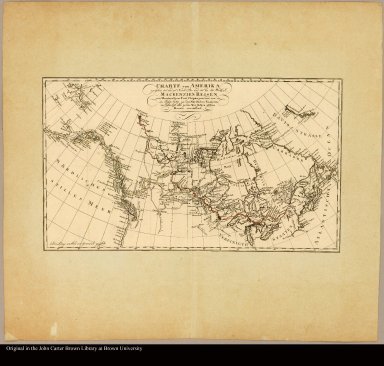
Detail View: JCB Map Collection: Charte von Amerika zwischen 40° und 70° Nord-Br. und 45° bis 180 Westl. L. Mackenzie's Reisen von Montreal zum Fort Chipewyan und von da im Kahre 1789 zu dem Nördlichen Eismeere, im Jahre 1793 aber su dem Westlichen stillen Meere vorstellend

|
Accession Number:
|
16800
|
|
File Name:
|
16800-000
|
|
Call number:
|
Cabinet C802 MaA
|
|
Map title:
|
Charte von Amerika zwischen 40° und 70° Nord-Br. und 45° bis 180 Westl. L. Mackenzie's Reisen von Montreal zum Fort Chipewyan und von da im Kahre 1789 zu dem Nördlichen Eismeere, im Jahre 1793 aber su dem Westlichen stillen Meere vorstellend
|
|
Place of Publication:
|
Hamburg
|
|
Publication date:
|
1802
|
|
Map size height:
|
28 cm.
|
|
Map size width:
|
47 cm.
|
|
Item description:
|
Engraved map, colored
|
|
Geographical description:
|
Map of the northern part of North America. Includes the Great Lakes, Hudson Bay [Canada], and the southern coast of Alaska.
|
|
Cartobibliographic notes:
|
From Alexander Mackenzie, "Reisen von Montreal durch Nordwest-amerika ..." Hamburg, 1802
|
|
Geographic Area:
|
North America
|
|
Normalized date:
|
1802
|
|
LC bibliographic number:
|
5343206
|
|
Creator:
|
Mackenzie, Alexander, 1764-1820
|