Detail View: JCB Map Collection: Plan of the Battery call'd Fort William, on the East side Willoughby Bay.
|
Accession Number:
|
28988
|
|
File Name:
|
28988-8
|
|
Call number:
|
Codex Eng 191 / 2-SIZE
|
|
Map title:
|
Plan of the Battery call'd Fort William, on the East side Willoughby Bay.
|
|
Place of Publication:
|
[Antigua]
|
|
Publication date:
|
[1752]
|
|
Map size height:
|
36.4 cm.
|
|
Map size width:
|
21.8 cm.
|
|
Item description:
|
fold-out manuscript map 7, hand coloring
|
|
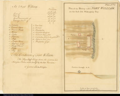
Geographical description:
|
Diagram of the battery called Fort William on the east of Willoughby Bay on the southeast side of Antigua. Includes scale and topographical details, as well as an illustration of a barbette or low wall over which guns or cannon were fired, guard house, magazine, and flagstaff. Includes an inventory of supplies associated with the fort and a report on hurricane damage.
|
|
Source author:
|
Horneck, Kane William
|
|
Source title:
|
A report of the state of the fortifications In the island of Antigua and particularly those of English Harbour In the said island in the year 1752.
|
|
Source place:
|
[Antigua]
|
|
References:
|
John Carter Brown Library, Annual Report, 1941, p. 22-25
|
|
Geographic Area:
|
Caribbean
|
|
Historical notes:
|
Kane William Horneck was the surveyor of these maps. Antigua served as the headquarters for the British Caribbean fleet which was based at English Harbor during the late eighteenth century.
|
|
Normalized date:
|
1752
|