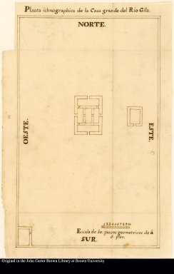
Detail View: JCB Map Collection: Planta ichnographica de la Casa grande del Rio Gila

|
Accession Number:
|
C-0153
|
|
File Name:
|
C-0153
|
|
Call number:
|
Cabinet Cg777 /3 Ms.
|
|
Map title:
|
Planta ichnographica de la Casa grande del Rio Gila
|
|
Place of Publication:
|
Tubutama [Mexico]
|
|
Publication date:
|
1777
|
|
Map size height:
|
27.7 cm.
|
|
Map size width:
|
17.1 cm.
|
|
Item description:
|
manuscript
|
|
Geographical description:
|
Plan of the Casa Grande or grand house at the Gila River. Includes scale.
|
|
Geographic Area:
|
North America
|
|
Historical notes:
|
Font describes the Casa Grande as also being known as the Palace of Moctezuma. Archeologists now think that Casa Grande, the first prehistoric and cultural site to be established in the United States (in 1892), was built by the Huhugam or Hohokam ("those who have gone") with caliche from the soil reinforced with wooden beams into a three-story building that may have served multiple purposes. Font trained at the College of the Holy Cross of Querétaro, Mexico, and was assigned to the Mission San José de Pimas in Sonora, New Spain. Because of his expertise with navigational equipment, he accompanied Juan Bautista de Anza on a trek to Alta California from the Tubac Presidio. His diary, the extended version of which is at the John Carter Brown Library, is considered the best account of Anza's expedition to establish a Spanish base on the North American west coast.This plan was removed from the diary and is held separately.
|
|
Normalized date:
|
1777
|
|
Creator:
|
Pedro Font
|