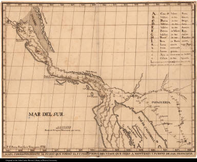
Detail View: JCB Map Collection: Mapa correspondiente al diario que formó el P. F. Pedro Font des viage que hizo a Monterey y puerto de San Francisco.
|
Accession Number:
|
C-0155
|
|
File Name:
|
C-0155
|
|
Call number:
|
Cabinet Cg776 /1 Ms.
|
|
Map title:
|
Mapa correspondiente al diario que formó el P. F. Pedro Font des viage que hizo a Monterey y puerto de San Francisco.
|
|
Place of Publication:
|
[Tubutama, Mexico]
|
|
Publication date:
|
1776
|
|
Map size height:
|
36.9 cm.
|
|
Map size width:
|
46.3 cm.
|
|
Item description:
|
manuscript
|
|
Geographical description:
|
Plan of part of the coast of present-day California from San Francisco to Baha California. Cartographic elements include lines of latitude and longitude, scale, sea banks or shoals, some topographical details, location of roads, presidios, churches, and indication of the length of leagues between various missions. Items in the map are lettered for identification in key at right.
|
|
Geographic Area:
|
North America
|
|
Historical notes:
|
Font trained at the College of the Holy Cross of Querétaro, Mexico, and was assigned to the Mission San José de Pimas in Sonora, New Spain. Because of his expertise with navigational equipment, he accompanied Juan Bautista de Anza on a trek to Alta California from the Tubac Presidio. His diary, the extended version of which is at the John Carter Brown Library, is considered the best account of Anza's expedition to establish a Spanish base on the North American west coast.This map was removed from the diary and is held separately.
|
|
Normalized date:
|
1776
|
|
Creator:
|
Pedro Font
|