Detail View: JCB Map Collection: Carte du Gouvernement de Cayenne ou France Aequinoctiale.
|
Accession Number:
|
04762
|
|
File Name:
|
04762-7
|
|
Call number:
|
E700 F927r
|
|
Map title:
|
Carte du Gouvernement de Cayenne ou France Aequinoctiale.
|
|
Place of Publication:
|
[Paris]
|
|
Publisher:
|
[Nicolas Le Gras]
|
|
Publication date:
|
[1700]
|
|
Map size height:
|
12.1 cm.
|
|
Map size width:
|
15.5 cm.
|
|
Item description:
|
fold-out engraved map; following p. 166
|
|
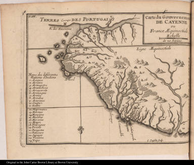
Geographical description:
|
Map of the eastern coast of South America from the Amazon River to the Marony River. Cartographic elements include compass rose, scale, topographical details and names of rivers, and names of settlements including Cayenne. Areas are numbered so that locations of native American tribes can be identified in key at left. Brazil is identified as Portuguese territory, and Surinam is identified as Dutch.
|
|
Source author:
|
Froger, François, b. 1676
|
|
Source title:
|
Relation d'un voyage fait en 1695. 1696. & 1697. aux côtes d'Afrique, Détroit de Magellan, Brezil, Cayenne, & Isles Antilles, par une escadre des vaisseaux du roy, commandée par Monsieur de Gennes. ...
|
|
Source place:
|
A Paris : Nicolas Le Gras, 1700
|
|
Geographic Area:
|
South America
|
|
Historical notes:
|
Admiral de Gennes had two purposes in this voyage supported by Louis XIV --to create trouble for Spain and to take booty. Six ships sailed ostensibly to establish a colony at the Strait of Magellan. They stopped on the African coast where they raided a fort, taking slaves and goods that were then sold by one of the ships in the Antilles. The other ships continued on to Rio de Janeiro and down the South American coast to the Strait of Magellan, but they had to turn back due to a shortage of food. They returned to La Rochelle in April 1697.
|
|
Normalized date:
|
1700
|
|
Creator:
|
C. Inselin
|