Detail View: JCB Map Collection: Draft of Disko Island and The Adjacent Coasts of Western Greenland.
|
Accession Number:
|
03420
|
|
File Name:
|
03420-16
|
|
Call number:
|
D818 O66g / 1-SIZE
|
|
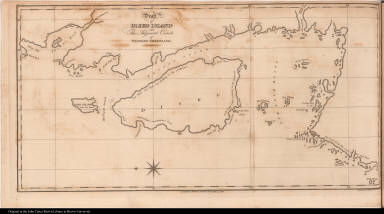
Map title:
|
Draft of Disko Island and The Adjacent Coasts of Western Greenland.
|
|
Place of Publication:
|
[London]
|
|
Publisher:
|
Baldwin, Cradock & Joy
|
|
Publication date:
|
1818
|
|
Map size height:
|
24.9 cm.
|
|
Map size width:
|
49 cm.
|
|
Item description:
|
fold-out engraved map; following p. 154
|
|
Geographical description:
|
Map of Disko Island and adjacent parts of western Greenland. Includes Lievely Point. Cartographic elements include compass rose, lines of longitude and latitude, and names of geographical locations
|
|
Source author:
|
O'Reilly, Bernard
|
|
Source title:
|
Greenland, the adjacent seas, and the North-west Passage to the Pacific Ocean, illustrated in a voyage to Davis's Strait, during the summer of 1817. ...
|
|
Source place:
|
London : Printed for Baldwin, Craddock, and Joy, 1818
|
|
Cartobibliographic notes:
|
Title page states that the plates are taken from drawings done by the author on the spot.
|
|
Geographic Area:
|
Polar
|
|
Historical notes:
|
This voyage was made by the whaling ship Thomas with O'Reilly serving as ship's surgeon. O'Reilly claims to have discovered the Linnaean Island Chain and is confident of the discovery of a northwest passage. Although O'Reilly made many of the observations in the book, it is believed that large parts of the text were plagiarised from the lectures of Professor von Giesecke.
|
|
Normalized date:
|
1818
|
|
Creator:
|
J. C. Russell
|