Detail View: JCB Map Collection: Isle de la Iamaique Divisée Par Paroisses Ou Sont Exactement Remarques les Ports et les Bayes
|
Accession Number:
|
01903
|
|
File Name:
|
01903-14
|
|
Call number:
|
E674 R311d (copy 1)
|
|
Map title:
|
Isle de la Iamaique Divisée Par Paroisses Ou Sont Exactement Remarques les Ports et les Bayes
|
|
Place of Publication:
|
[Paris]
|
|
Publisher:
|
[Louïs Billaine]
|
|
Publication date:
|
[1674]
|
|
Map size height:
|
27.6 cm.
|
|
Map size width:
|
31.5 cm.
|
|
Item description:
|
fold-out engraved map; before p. 1 (fourth count)
|
|
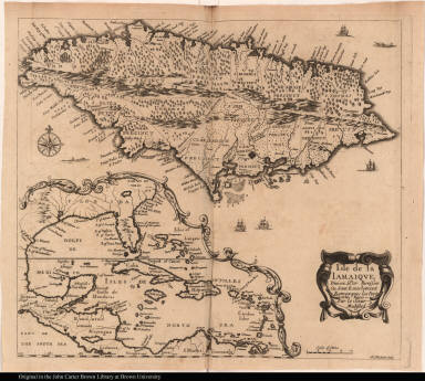
Geographical description:
|
Map of Jamaica with inset map of the Caribbean area including North America as far north as Virginia, Central America, and the northernmost part of South America. Cartographic elements include scale, compass rose, shoals or sea banks, soundings, topographical details, names of parishes, towns, and bodies of water. Also includes decorative fish and ships.
|
|
Source title:
|
Recueil de divers voyages faits en Afrique et en l'Amerique, qui n'ont point esté encore publiez; contenant l'origine, les moeurs, les coûtumes & le commerce des habitans de ces deux parties du monde.
|
|
Source place:
|
A Paris, : Chez Louïs Billaine, dans la Grand' Salle du Palais, au second pillier, au grand Cesar., M. DC. LXXIV.
|
|
Geographic Area:
|
Caribbean
|
|
Historical notes:
|
Includes translations from English, Portuguese, Latin, etc., in 8 sections. The order of the sections varies among copies, as do the order and number of leaves of plates. Compiled and edited by Henri Justel.This section is Description de L'Isle de la Jamaique by Sir Thomas Modyford. Modyford, who became governor of Jamaica in 1664 when he arrived with 1000 settlers from Barbados, is supposed to have divided the island into seven parishes (fewer than are shown here). He is also credited with bringing the cultivation of sugar to Jamaica and with having supported the activities of privateers and bucaneers as a defense against the Spanish.
|
|
Normalized date:
|
1674
|
|
Creator:
|
R. Michault
|