Detail View: JCB Map Collection: Cosmographia vniversalis et exactissima ivxta postremam neotericorvm traditionem ...
|
Accession Number:
|
31961
|
|
File Name:
|
31961-1
|
|
Call number:
|
Cabinet A 569 / 1
|
|
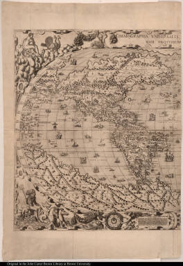
Map title:
|
Cosmographia vniversalis et exactissima ivxta postremam neotericorvm traditionem ...
|
|
Place of Publication:
|
Venetijs[Venice]
|
|
Publisher:
|
Ad signum Pyramidis
|
|
Publication date:
|
M.D.LXIX [1569]
|
|
Map size height:
|
62.3 cm.
|
|
Map size width:
|
52.3 cm.
|
|
Item description:
|
engraving
|
|
Geographical description:
|
World map, 4 sheets in 2, includes North and South America with the Strait of Anian and California shown as part of the continent. These two sheets show North and South America. Cartographic elements include lines of latitude and longitude, wind rose, location of rivers, settlements, and some topographical details. Decorative elements include mythological figures representing the sea (Neptune or Poseidon with his chariot drawn by sea horses or hippocampi), the air (Juno or Hera with her chariot drawn by peacocks), fire (Vulcan, the blacksmith of the gods, with his anvil, hammer, and forge), and the earth (Cybele or Rhea [or perhaps Ceres [?] or Demeter, goddess of agriculture], with cornucopia and her chariot drawn by lions). Also includes camel, rhinoceros, and lion (in North America), ships, sea monsters or fish, angels, and satyrs.
|
|
References:
|
Shirley, R.W. Mapping of the world, 117, John Carter Brown Library, Annual Reports, 1957, p. 25-30; Beans, G.H. Large world map by J.F. Camotius; Gallo, R. "Gioan Francesco Camucio," Imago Mundi, 1950
|
|
Geographic Area:
|
World
|
|
Historical notes:
|
This map, perhaps engraved by Nicolo Nelli in Venice, was (with Zaltieri's 1566 map of North America) the first map to be based on Gastaldi's world map of 1561. It is one of the earliest extant maps showing the strait of Anian.This map was first published in 1567.
|
|
Normalized date:
|
1569
|
|
Creator:
|
Giovanni Francesco Camocio
|