Detail View: JCB Map Collection: Carte de la Guyane Française et l'Isle de Cayenne
|
Accession Number:
|
35736
|
|
File Name:
|
35736-1
|
|
Call number:
|
E798 P971v
|
|
Map title:
|
Carte de la Guyane Française et l'Isle de Cayenne
|
|
Place of Publication:
|
[Paris]
|
|
Publication date:
|
An VI de la République [1798]
|
|
Map size height:
|
23.5 cm.
|
|
Map size width:
|
37.4 cm.
|
|
Item description:
|
fold-out engraved map; frontispiece, hand coloring
|
|
Geographical description:
|
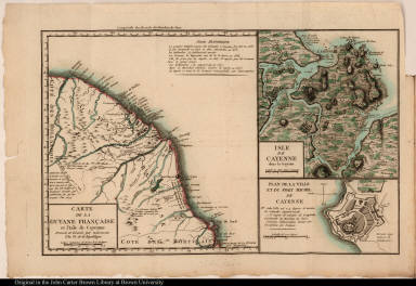
Map of the coast of French Guiana including two inset maps, one of the island of Cayenne, the other a plan of the town and Fort Michel of Cayenne. Cartographic elements include scales, degrees of latitude and longitude, and some topographical details. Also includes fortifications.
|
|
Source author:
|
Prudhomme, Louis Marie, 1752-1830
|
|
Source title:
|
Voyage a la Guiane et a Cayenne ...
|
|
Source place:
|
A Paris : Chez l'éditeur, rue des Marais, no. 20, F.G., an VI de la Republique.
|
|
Geographic Area:
|
South America
|
|
Historical notes:
|
Prudhomme, a publisher and journalist who was active during the French Revolution, published this account of the Guianas in 1798.
|
|
Normalized date:
|
1798
|
|
Creator:
|
Dalencour
|