Detail View: JCB Map Collection: Isle de sainte Croix.
|
Accession Number:
|
0339
|
|
File Name:
|
0339-14
|
|
Call number:
|
E613 C453v [R]
|
|
Map title:
|
Isle de sainte Croix.
|
|
Place of Publication:
|
Paris
|
|
Publisher:
|
[Jean Berjon]
|
|
Publication date:
|
[1613]
|
|
Map size height:
|
14.7 cm.
|
|
Map size width:
|
25.2 cm.
|
|
Item description:
|
fold-out engraved map; following p. 34
|
|
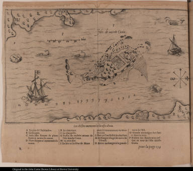
Geographical description:
|
Chart of the island of Sainte Croix, present-day Saint Croix or Dochet Island, Maine. Cartographic elements include soundings, scale, some topographical details, location and plan of settlement. Also includes fish and ships. Items in the image are lettered for identification in key below.
|
|
Source author:
|
Champlain, Samuel de, 1567-1635
|
|
Source title:
|
Les voyages du sieur de Champlain Xaintongeois, capitaine ordinaire pour le roy, en la marine.: ... ou, Iournal tres-fidele des obseruations faites és descouuertures de la Nouuelle France ... Cerchans vn chemin par le Nord, pour aller à la Chine
|
|
Source place:
|
Paris, : chez Iean Berjon, rue S. Iean de Beauuais, au Cheual volant, & en sa boutique au Palais, à la gallerie des prisonniers., M.DC.XIII
|
|
References:
|
http://www.nps.gov/sacr/history/history.htm (Aug. 2005)
|
|
Geographic Area:
|
North America
|
|
Historical notes:
|
Pierre Dugua, sieur de Mons, accompanied by Champlain and 77 other men, established one of the first European settlements in North America on St. Croix Island, but abandoned it in 1605.Champlain drew the original from which the engraving was made.
|
|
Normalized date:
|
1613
|