Detail View: JCB Map Collection: Les Côtes de la Virginie, les Detroits de Forbisher [sic] et de Hudson
|
Accession Number:
|
34182
|
|
File Name:
|
34182-5
|
|
Call number:
|
E720 R382d2
|
|
Map title:
|
Les Côtes de la Virginie, les Detroits de Forbisher [sic] et de Hudson
|
|
Place of Publication:
|
[Amsterdam]
|
|
Publisher:
|
[Jean Frédéric Bernard]
|
|
Publication date:
|
[1720]
|
|
Map size height:
|
15.1 cm.
|
|
Map size width:
|
23 cm.
|
|
Item description:
|
fold-out engraved map; following p. [382]
|
|
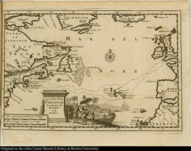
Geographical description:
|
Map of the north Atlantic Ocean including the routes of Martin Frobisher and Henry Hudson from England to Cape Cod. Includes the mouth of the Saint Lawrence River and Hudson Strait. Cartographic elements include sea banks or shoals, degrees of latitude and longitude, compass rose, and scales. Decorative cartouche includes European encounter with native Americans, ships, and parasol.
|
|
Source title:
|
Relations de la Louisiane, et du fleuve Mississipi ...
|
|
Source place:
|
A Amsterdam, : Chez Jean Frederic Bernard, M.DCC.XX
|
|
Cartobibliographic notes:
|
This work is drawn from material that originally appeared in volume 5 of Jean Bernard, Recueil de voyages au Nord, Amsterdam, 1715. It also includes Henri Tonti, Dernières découvertes, Paris, 1697, and Louis Hennepin, Nouveau voyage, Utrecht, 1698.
|
|
Geographic Area:
|
North America
|
|
Normalized date:
|
1720
|