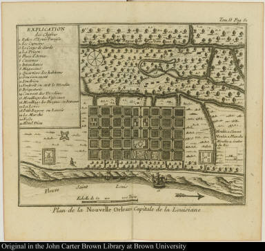
Detail View: JCB Map Collection: Plan de la Nouvelle Orleans Capitale de la Louisiane

|
Accession Number:
|
07250
|
|
File Name:
|
07250-1
|
|
Call number:
|
E753 D893m (copy 1)
|
|
Map title:
|
Plan de la Nouvelle Orleans Capitale de la Louisiane
|
|
Place of Publication:
|
[Paris]
|
|
Publisher:
|
[Cl. J. B. Bauche]
|
|
Publication date:
|
[1753]
|
|
Map size height:
|
11.7 cm.
|
|
Map size width:
|
15 cm.
|
|
Item description:
|
engraved map; vol. 2, following p. 51
|
|
Geographical description:
|
Plan of New Orleans, Louisiana, shown on the Saint Louis (present-day Mississippi) River. Cartograpical elements include scale, location of fortifications, churches, and squares. Items in the image are numbered for identification in key to the left.
|
|
Source author:
|
Dumont de Montigny, lieutenant
|
|
Source title:
|
Mémoires historiques sur la Louisiane ... Tome second
|
|
Source place:
|
A Paris, : Chez Cl. J.B. Bauche, libraire, quai des Augustins, à l'image Ste Geneviéve., M.DCC.LIII.
|
|
Geographic Area:
|
North America
|
|
Historical notes:
|
This memoir by Jean-François Benjamin Dumont de Montigny was edited by Jean-Baptiste le Mascrier.Two volumes bound together.
|
|
Normalized date:
|
1753
|