Detail View: JCB Map Collection: [Albemarle Sound, North Carolina]
|
Accession Number:
|
8189
|
|
File Name:
|
8189-21
|
|
Call number:
|
Cabinet Blathwayt 21
|
|
Map title:
|
[Albemarle Sound, North Carolina]
|
|
Place of Publication:
|
[London]
|
|
Publication date:
|
1679
|
|
Map size height:
|
48.3 cm.
|
|
Map size width:
|
64.2 cm.
|
|
Item description:
|
manuscript, hand coloring
|
|
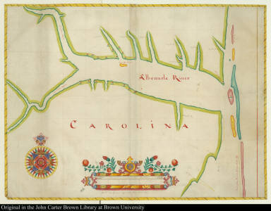
Geographical description:
|
Chart of Albemarle Sound, North Carolina. Cartographic elements include degrees of latitude, decorative scale, compass rose, location of capes, plantations, and rivers.
|
|
Cartobibliographic notes:
|
One of four Carolina manuscripts in the Blathwayt Atlas drawn by map makers of the Thames school. This map is the only known example of the work of James Lancaster (not thought by Jeannette Black to have been the creator of the other maps of Carolina in the Blathwayt Atlas). Perhaps it was made to aid discussion of the Culpeper Rebellion which disturbed the Albemarle region from 1677 to 1680. The location of 23 plantations on the map gives rare evidence of landholding by Carolina proprietors.The Blathwayt Atlas is a collection of 48 maps assembled between 1680 and 1685 as a reference atlas for the Office of Trade and Plantations, compiled by William Blathwayt, Secretary to the Lords of Trade and Plantations.
|
|
References:
|
Black, J.D., ed. Blathwayt Atlas, vol. II, p. 137-140; Cumming, W.P. Southeast in early maps, 81
|
|
Geographic Area:
|
North America
|
|
Normalized date:
|
1679
|
|
Creator:
|
James Lancaster
|