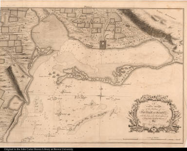
Detail View: JCB Map Collection: A Correct Draught of the Harbours of Port Royal and Kingston, with the Keys and Shoals adjacent &c. ...

|
Accession Number:
|
64-27
|
|
File Name:
|
64-27-1
|
|
Call number:
|
D756 B883c / 2-SIZE
|
|
Map title:
|
A Correct Draught of the Harbours of Port Royal and Kingston, with the Keys and Shoals adjacent &c. ...
|
|
Place of Publication:
|
[London]
|
|
Publisher:
|
[T. Osborne and J. Shipton]
|
|
Publication date:
|
[1756]
|
|
Map size height:
|
48.1 cm.
|
|
Map size width:
|
68.3 cm.
|
|
Item description:
|
fold-out engraved map; following p. viii
|
|
Geographical description:
|
Map and chart of Port Royal and Kingston, Jamaica. Cartographic elements include scale, soundings, locations of shoals or sea banks, names of bodies of water and geographical features, locations of gun batteries, fortifications, and buildings. Cartouche includes cannons, flags, swords, trumpets, muskets or guns, and pikes.
|
|
Source author:
|
Browne, Patrick, 1720?-1790
|
|
Source title:
|
The civil and natural history of Jamaica ...
|
|
Source place:
|
London : Printed for the author; and sold to T. Osborne, and J. Shipton, in Gray's-Inn., MDCCLVI
|
|
Geographic Area:
|
Caribbean
|
|
Historical notes:
|
Jamaica was captured from the Spanish by the English in 1655. Port Royal was built on a spit of sand as a defensive fort to protect the harbor; it became one of the largest and most commercially important English towns in the Americas. It was also home to a great deal of pirate activity. On June 7, 1692, 33 acres of the town fell into the sea as the result of an earthquake. The town was rebuilt in 1702, but a storm, a hurricane, and two earthquakes in 1722 destroyed it finally. Only a small spit of land remains of what was a much larger peninsula.Browne was an Irish medical doctor who settled in Jamaica in 1746. There he collected 1200 species of plants, 400 more than Sloane. He retired to Ireland in 1771.
|
|
Normalized date:
|
1756
|
|
Creator:
|
J. Mynde
|
|
Creator:
|
Richard Jones
|