Detail View: JCB Map Collection: A New Map of the Isthmus of Darian in America & Bay of Panama The Gulph of St. Michal with Its Islands, & Countries Adjacent
|
Accession Number:
|
952
|
|
File Name:
|
952-1
|
|
Call number:
|
D Scott 63
|
|
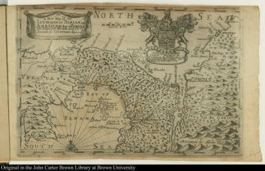
Map title:
|
A New Map of the Isthmus of Darian in America & Bay of Panama The Gulph of St. Michal with Its Islands, & Countries Adjacent
|
|
Place of Publication:
|
[Edinburgh]
|
|
Publisher:
|
[John Mackie and James Wardlaw]
|
|
Publication date:
|
[1699]
|
|
Map size height:
|
16.8 cm.
|
|
Map size width:
|
25.3 cm.
|
|
Item description:
|
fold-out engraved map; following title page
|
|
Geographical description:
|
Map of the isthmus of Darien showing Central America from Porto Bello to Cartagena. Cartographic elements include topographical details, degrees of latitude and longitude, location of rivers, islands, sea banks or shoals, compass rose, and scale. Decorative elements include coat of arms of the right honorable John, marques of Tweedale, earl of Gifford, viscount Walden, Lord Hay of Yester [?] to whom the map is dedicated.
|
|
Source title:
|
A letter, giving a description of the Isthmus of Darian: (where the Scot's colonie is settled;) ...
|
|
Source place:
|
Edinburgh : Printed for John Mackie, in the Parliament-Closs, and James Wardlow on the north side of the Street a little below the Cross, at the sign of Bible, M. DC. XC. IX
|
|
Geographic Area:
|
South America
|
|
Historical notes:
|
This publication was the first comprehensive eyewitness account of the new settlement at Darien founded by the Company of Scotland Trading to Africa and the Indies.
|
|
Normalized date:
|
1699
|